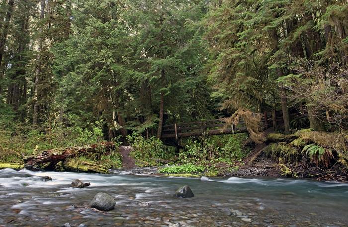
A bridge crosses Barnes Creek just below Marymere Falls in Olympic National Park/Scott Johnson
There’s a reason that Washington is called the Evergreen State.
People from the scablands and rolling hills east of the Cascades may smirk at that moniker, but anyone who’s set foot in the lush, ancient forests of Olympic National Park knows the type of scenery that inspired such a nickname. We’re talking ferns blanketing the ground and mosses dangling from gigantic Sitka spruce, with vistas revealing treetops all the way to the horizon.

Green is in the canopy and on the ground along the Ancient Groves Trail/Scott Johnson
The vast park – nearly 923,000 acres, 95 percent of it designated wilderness – encompasses much of the Olympic Peninsula that juts out to the Pacific Ocean at the northwest corner of the country, Canada’s Vancouver Island visible across the Strait of Juan de Fuca. The truly unique landscape quickly climbs from over 70 miles of rugged coastline to nearly 8,000 feet elevation at the top of Mount Olympus; in between, old-growth forests and vegetation thrive, nourished by about 150 inches of annual precipitation dumped as storms from the ocean encounter a wall of mountains.
In other words, expect to be overwhelmed by green (and likely rain) no matter what time of year you visit.
In early May, an appointment afforded my wife and I enough time and proximity to make a one-day detour to Olympic National Park. Of course, a single day meant we had to be picky. So although the road to the alpine wonders of Hurricane Ridge was open and the conditions unexpectedly turned out to be perfect for a day at the beach, we focused our itinerary on the dense forests and rushing waterfalls quickly accessible from U.S. Highway 101. The road circles much of the park, with arteries running in and out to developed areas and trailheads. What isn’t part of the national park seemingly is either national or state forest, some of it harvested. But since the highway travels around, instead of through, much of the park, it takes a little time to get from one sight to the next.
We awoke to sunny skies in Port Angeles, on the north end of the peninsula and home to the park’s headquarters. The air was crisp but not chilly – better than expected considering the season. We hit the road before the visitor center opened, heading west and spotting the snow-capped peaks in the distance to the south. Our hotel for that night, in Aberdeen, was beyond those mountains. Only 160 miles of pavement away, it would take until well past sunset to get there.

The Elwha River braids its way toward the former location of the Glines Canyon Dam, which used to form Lake Mills reservoir/Scott Johnson
Elwha Valley
My only other trip to Olympic came in the fall of 2009, after a fairly dry summer, so this short adventure, in the spring after a particularly wet winter, inspired a feeling of renewal. Perhaps nowhere in Olympic is that sensation of rebirth felt more strongly than in the Elwha Valley.
Often bypassed as tourists speed toward Lake Crescent, the Elwha River has become a symbol and concrete example of the power of restoration. Starting in 2011 and completed in 2014, two dams built in the early 1900s were decommissioned and demolished, making it the largest dam-removal project in U.S. history. The Elwha now flows freely for the first time in over a century, and the Park Service has worked to revegetate river banks previously hidden deep beneath the reservoirs. Salmon, once prolific and important to both native tribes and fish-dependent wildlife such as eagles and bears, have returned to spawn, no longer blocked by walls of concrete.
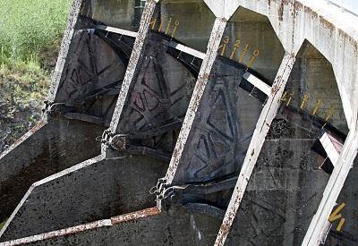
Portions of Glines Canyon Dam were left behind to serve as an outdoor exhibit/Scott Johnson
Without the dams in place, the river has begun to reclaim its natural course, which has had consequences for visitors. Both the Elwha and Altair campgrounds are closed indefinitely due to flooding and the Elwha River’s changing course. Another victim was Olympic Hot Springs Road, which leads into the valley. It reopened in January after being closed since November 2015, when a series of storms wiped out 90-foot section of pavement.
During my visit, the road was open to Glines Canyon, the former location of one of the dams. I wanted to see what such a place would look like, three years removed from the final blasts that took down the 210-foot-tall arch dam. You can see the appeal of Glines Canyon, where the river squeezes through a deep channel en route to the Strait of Juan de Fuca. Only now, the Elwha braids down a wide valley instead of pooling at Lake Mills. Plants have filled in the former lakebed. The sounds of generators have been replaced by a running river and chirping birds.
Remnants of the structure left intact atop Glines Canyon serve as an outdoor exhibit. What once was the top of the dam has been turned into a short promenade, with informational signs and machines that play audio clips about the history of the area and the restoration project. Those brave enough can lean over the railing and peer down to the river crashing into the walls below. The concrete skeleton is a testament to the power of man – both to tame and untame. Untamed suits the Elwha well.
On your way in or out of the Elwha Valley, make sure to stop at the trailhead for Madison Falls, a few miles off the highway and just inside the park boundary. The Elwha rushes beside the road, and a grassy clearing makes a nice spot for a picnic. A massive tree stump, which would likely take five people to wrap their outstretched arms around, marks the starting point for the short, accessible trail to Madison Falls. The 76-foot cascade hugs a moss-lined cliff as it drops into a peaceful, shaded hollow. Although pretty, it lacks the majesty of other nearby waterfalls. Consider both the tree stump and the waterfall a taste of what’s ahead.
Marymere Falls
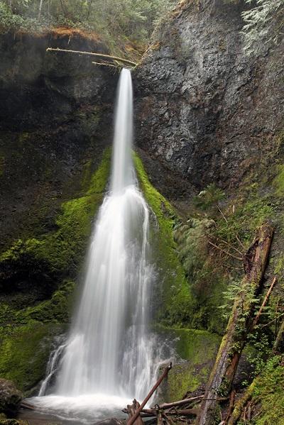
Not far from Lake Crescent, Marymere Falls is a picture of grace/Scott Johnson
“We don’t have waterfalls like this in Vermont,” a woman said.
“Not like these,” her husband confirmed.
Their necks craned to take in the full view of Marymere Falls. A thin streak of water pours over the cliff, widening drop by drop as it hits one shelf and then another. A large tree branch (or small trunk) teeters over the brink the falls, seemingly ready to join a collection of woody debris 119 feet below at any moment, but based on a photo from my first trip, it has been hanging there for at least eight years. From the lower platform, a short loop includes a staircase to a different perspective, though the view from the upper platform has become slightly obscured by surrounding foliage.
This beautiful cascade is a popular spot in Olympic, as the gentle, 1.5-mile roundtrip hike starts at the Storm King ranger station on the shore of Lake Crescent. The lake laps right up to Highway 101, and we were fortunate to visit before a three-year construction project begins this summer. The enthusiastic receptionist at our hotel in Port Angeles urged us to make the steep hike up Mount Storm King for an impressive view of the glacier-carved, blue-green lake, but that wasn’t in the cards for this trip. We passed the turnoff in favor of Marymere Falls. Even if you don’t need a break along the trail, a rocky bar along Barnes Creek just below the falls is a nice place to take in the scene. In the fall, you can find huge yellow and orange maple leaves here.
None of the visitor facilities at Storm King had opened for the season, so the area was relatively quiet, particularly for a Saturday, but a group of youths were working with a ranger to either pull invasive weeds or plant native vegetation. Work to restore Olympic continues beyond the Elwha.
Sol Duc Valley
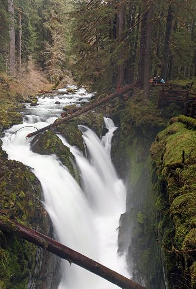
A bridge over the river is a prime spot to watch Sol Duc Falls plunge over a cliff/Scott Johnson
Whereas Marymere Falls is a picture of grace, Sol Duc Falls is a thundering force.
That change of mood manifested in the weather. It began to rain hard enough that my wipers, even at the highest setting, couldn’t keep up. Along the 14-mile access road through the Sol Duc Valley, huge trees stand only a couple feet from the pavement, their roots creating bulges in the pavement. Things were looking ominous. Yet after we reached the parking lot for Sol Duc Falls, the storm cleared as we ate lunch.
A resort (with hot springs) and campground just up the road means this trail is well-trafficked, but the rain seemed to clear out many of the hikers, and we saw only a handful of small groups. Patches of white trillium with three petals bloomed along parts of the walk, although green dominated the scenery, with moss covering tree trunks and boulders all along the way.
In less than a mile, a wooden shelter built by the CCC signified that the falls were near. While a rustic footbridge that looks to be from the same era leads to a viewpoint, this is the place to stop and breathe in the scene. In one direction, the river appears through the trees, then splits into four channels as it plummets 40 feet down the side of a cliff into a narrow cauldron, spraying you with mist. The river roars below you and disappears into a box canyon. We marveled with another couple about what it must have been like to build the iconic footbridge we were standing on. Past the bridge, there are closer vantage points with even heavier mist. Exploring above the falls provides a view of the falls framed by the bridge, but don’t get too close to the edge.
On our return to the parking lot, another couple said they spotted a bear along the trail, but it must have moved on before we passed through.
Before heading to the Hoh Rain Forest, we stopped for a taste of old-growth on our way out of the Sol Duc Valley. The Ancient Groves Trail loops around a small pond and to views above the Sol Duc River, and even though it never strays more than a quarter-mile from the road, the tall trees drown out the impression that civilization is anywhere nearby.
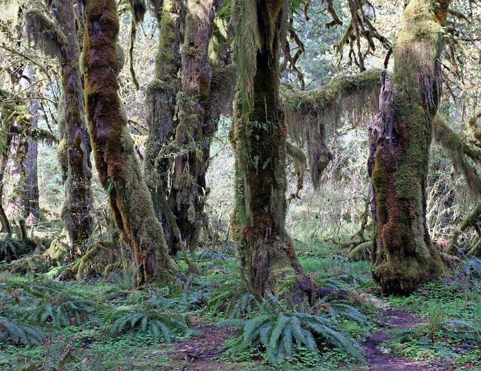
An impressive stand of maple trees can be found along the Hall of Mosses Trail in the Hoh Rain Forest/Scott Johnson
Hoh Rain Forest
It’s saying something about a forest when even the fallen trees are a sight to behold. But the Hoh Rain Forest isn’t just any other forest. The trees aren’t as tall as redwoods or sequoias, but the green draperies that hang from the limbs give the ambiance of a cathedral. A park brochure explains that epiphytes (plants growing upon other plants) “give the rain forest its characteristic look and ethereal quality.”
An 18-mile road from the highway leads to a new visitor center, remodeled in 2015, that was still missing the bulk of its exhibits. They are supposed to be in place later this year. I remembered seeing a telephone booth here years ago, but I couldn’t find it this time. From the visitor center, the excellent Hall of Mosses and Spruce Nature trails traverse a total of two miles of dense old-growth, with spruce, fir, hemlock, cedar, and maple trees towering overhead. While it can be tempting to only look upward, you can touch and feel the massive trees that have fallen along the paths. Standing at one end and looking down the length of a trunk, you get an understanding of just how large these trees are. Burbling Taft Creek is so clear that it appears to be green in some places, taking on the color of submerged plants.
Mostly, people speak in whispers out of awe and respect. There were exceptions, like the group of teens who noisily took childish pictures, but at least they were following all park rules and having a great time in nature. The same can’t be said for a couple of guys in the parking lot who were landing their drones, which are illegal to fly in national parks.
Throughout the day, we had seen warnings about all sorts of wildlife, including bears, Roosevelt elk (common in the Hoh), and even yellow jackets. But we hadn’t actually seen much wildlife. That finally changed near the end of our exploration. After passing a grove of maples, I saw a gray blob swoop down from the sky out of the corner of my eye. My attention piqued, I scanned through the mosses and ferns to try to figure out what it was. Just as I turned my head away, the blob zipped back up. Peering through tree branches, I spotted a gray puffball of an owl.
Not wanting to tramp off-trail, I grabbed my zoom lens and tried focus through a mess of foliage. In addition to keeping an eye on me, the owl was scanning for dinner and kindly posed for a few minutes before moving to a new perch out of my view. Later, when I asked my birder friends for identification, they tried to convince themselves it was a northern spotted owl (which can be found in the forests of Olympic), but to no avail. Definitely a barred owl.
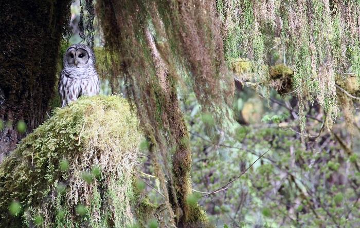
A barred owl searches for prey on a perch in the Hoh Rain Forest/Scott Johnson
The Hoh leaves an enduring impression, but it’s far from the only impressive rainforest in the park. However, we didn’t have time to stop at Queets or Quinault. We left the Hoh after having a snack for dinner, and with another two hours of driving to Aberdeen, we longingly looked at the sun-drenched beaches from the seats of our car when we passed them.
The quite obvious lesson is that one day isn’t enough time to experience even the roadside attractions of Olympic National Park, nonetheless the vast interior wilderness.


Add comment