

Cool Ponderosa pine forests, ancient life, and volcanism are all within reach this fall in Arizona’s high country. The gateway town of Flagstaff makes a perfect basecamp to visit four national monuments that protect ancient Native American dwellings and tell the stories of their occupants’ lives. Of course, the Grand Canyon to the north is the main draw for many visitors, but take some time to explore these lesser-known sites as well.
The stories within these monuments— Walnut Canyon, Sunset Crater Volcano, Wupatki, and Montezuma Castle—overlap, but a long weekend tour will provide you with a deeper understanding of some of the cultural and geologic mysteries of the Southwest. Designated by four different presidents, the monuments embrace a landscape dotted with well-sheltered cliff dwellings and shaped by volcanoes, while nearby you can view a meteor crater from 50,000 years ago.
Start your tour with a visit to Wupatki. Designated December 9, 1924, by President Calvin Coolidge, Wupatki is approximately an hour’s drive north of Flagstaff. Take Highway 89A north for a few dozen miles, and make the turn to the east to reach this unusual monument. (This is a 35-mile loop road that also accesses Sunset Crater Volcano National Monument, so you can choose not to backtrack.)
The visitor center is located next to the three-story Wupatki Pueblo, with its more than 100 rooms that once housed 300 people. There are more than 800 identified ruins here, tucked between the Ponderosa-dotted mountains and Painted Desert, and all with a distinctive dark red color of the native Moenkopi sandstone, punctuated with black volcanic sand.
Though first inhabited around 500 CE, there was an influx of residents after the volcanic eruptions of Sunset Crater in the 11th century; it was abandoned by 1215 CE.
The Wupatki Pueblo is thought to have been the largest, tallest, and most influential pueblo during those times. Hopi may have inhabited the buildings afterwards, and in the 1880s sheepherders used some of the structures as a camp.
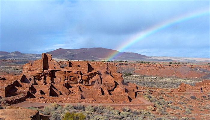
Wupatki National Monument holds more than 800 ruins, some of which you can inspect up close/NPS photos
There are five accessible ruins, and you might visit the Lomaki and Box Canyon pueblos via an easy half-mile trail. These pueblos are built on the edge of a deep canyon. The Citadel Pueblo is built on a small hill, with a limestone sinkhole to the south. Once you take a walk to one of these pueblos, you’ll spot other ruins dotting the desert. For a view, take the half-mile Doney Mountain Trail to the top of a volcanic cinder cone.
The park rangers also offer guided hikes during the cooler months, which will allow you to see areas of the monument otherwise not open to the public. Discovery Hikes are short day hikes, available on some Saturdays from November through March, where you’ll explore petroglyphs, archaeology, and the flora and fauna of the area.
During four weekends in October, the Crack in the Rock hikes are a two-day, weekend adventure into the backcountry, with participants chosen by lottery. This 25-mile, strenuous hike is limited to 12 people, and you must be able to carry your own backpack. A highlight of the trek is visiting the remote Crack-in-the-Rock Pueblo.
It’s too late to enter the lottery for this fall’s hikes, but check the park’s website next summer for the 2018 schedule. The hikes are also offered in April, so check in early spring if this sounds appealing.
There is no lodging, overnight parking, or camping at Wupatki, and there is a $5 per person entrance fee, that covers both Wupatki and Sunset Crater Volcano national monuments. Hiking schedules and more information are available at the visitor center, and online. -- Patrick Cone
Sunset Crater Volcano National Monument
From Wupatki, continue along the loop road and access the eastern entrance to Sunset Crater Volcano National Monument. On the way, stop at the Painted Desert Vista view, photograph the unique landscape, and marvel at the Kana-a lava flow. Stop again within the monument at the Cinder Hills Overlook, and look over the mix of volcanic flows, cones, and tubes, with meadows and Ponderosa pines interspersed between.
This monument was designated May 26, 1930, by President Herbert Hoover after a movie company proposed to blow up an area of this unique geologic area. You can take in a number of interpretive programs, and spend time at the visitor center getting acquainted with the natural and human history of the monument.

Sunset Crater is one of quite a few volcanic craters near Flagstaff/NPS
The monument embraces rugged terrain; in 1917, Grace Spradling wrote of a climb, “Well, it’s one of the queerest trails you ever saw for the whole mt in nothing but cinders. The trail goes nearly straight up the side of mt. and the cinders make it so you take 3 steps up slide back 2.”
For hikers, much of the rocky terrain is sharp, brittle, and unforgiving. Head to the Lava Flow Trail and you’ll find a self-guided, one-mile trail. Be sure to grab one of the interpretive booklets available at the visitor center before you take the hike.
Other options include two trails that leave the Lenox Crater trailhead. The Lenox Crater Trail is a one-mile, steep trail, and the Aa Flow Trail winds a quarter-mile through the lava flows. If you want a long hike, hike the seven miles to the top of O’Leary Peak, accessible from U.S. Forest Service lands.
Sunrise and sunsets here are spectacular— a photographer’s dream—with dark, starry skies and in the winter, a covering of snow. Then, complete your loop back to Flagstaff in 20 minutes along Highway 89. — Patrick Cone
Walnut Canyon National Monument
Just 10 minutes east of Flagstaff, on a densely forested plateau, the serpentine chasms of Walnut Canyon long ago gave refuge to hundreds of Native Americans. Once the Transcontinental Railroad reached northern Arizona, Walnut Canyon became a popular tourist spot and, in order to protect it from overuse, a section of the canyon was set aside with a declaration from President Woodrow Wilson on November 30, 1915.
Autumn mornings can be cool here, at over 6,600 feet, but by afternoon the sun has warmed the limestone and sandstone walls and canyons, perfect for a walk.
Occupied from approximately 1100 to 1250 CE, the Sinagua people were experts in growing crops and living in an arid environment. There are nearly 400 species of plants that they relied upon, including the Arizona black walnut and Prickly Pear cactus. The rims are forested with Ponderosa pine and Gambel oak, along with pinyon and juniper.

The Island Trail at Walnut lets you explore several cliff dwellings and offers great views down into the bottom of the canyon/Patrick Cone
Along the trail it’s a simple matter to imagine life in these canyons; hauling water from the creek, tending fields on the rim, and sheltering from cold winds inside these stone rooms. Since the rooms were built under limestone overhangs, there are no roof beams, and they were also constructed with a front stone porch. Inside the visitor center a wall-to-floor glass wall lets you gaze down into the 400-foot deep canyon.
The visitor center showcases artifacts ranging from hunting points, metate grinding stones, and even items affected by the nearby eruptions from Sunset Crater.
You can walk the 0.7-mile Rim Trail with its sprawling views into the canyons, or head down the one-mile Island Trail loop, which is more strenuous. The paved loop trail drops 185 feet, with more than 240 steps, but it’s worth the effort. You’ll pass more than 25 cliff dwellings, with a steep climb to come back up to the rim. In the late fall and winter, this trail is sometimes closed due to snow and ice. -- Patrick Cone
Montezuma Castle National Monument
First off, Montezuma never made it this far north, but that didn’t keep 19th century settlers from naming this spectacular cliff dwelling after the Aztec leader. An hour south of Flagstaff, it was designated on December 8, 1906, by President Theodore Roosevelt.
The dwelling rises five stories, tucked nicely within an alcove 50 feet above the valley floor. The Southern Sinagua people (who lived in this towering residence from about 1125 AD-1400 CE) chose their location wisely: they had protection from the elements, the south-facing dwelling was warmed in winter by the sun, and the height provided a great perspective of the surrounding landscape. A nearby creek provided water for their crops.
A short sidewalk leads from the visitor center to some nice vantage points of the castle, which probably housed about 35 people. Take a seat on a bench for a few minutes and ponder the craftsmanship of the Sinagua people, who built this 20-room dwelling so high off the valley floor.
“This was a pretty heavily populated area, lots of dwelling spaces,” National Park Service volunteer Judith Biery said. She said that the area in and around today’s national monument was a melting pot of sorts roughly 1,000 years ago. They were hunter-gatherers, migratory cultures, and farmers, she explained. Ten miles to the north, a deep spring named Montezuma Well is part of the monument and was well used by Native Americans.
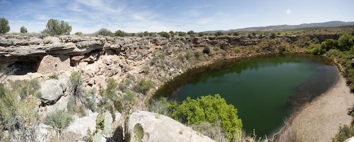
After exploring inside Montezuma Well, hike down and around to where the outlet drains the pool/Patrick Cone
At Montezuma Well, a few cliff dwellings can be seen just beneath the rim that rises above and encircles the water, and some pueblos existed above the rim. More dwelling spaces can be found inside the rim down near the water. One, the Swallet Cave Ruin, is a rock shelter that had nine rooms.
The farmers who lived here from roughly 900 CE to about 1400 CE made great use of the water source, which puts out an estimated 1.5 million gallons of water a day. From a small drain across from the Swallet ruin, water courses underground for a short distance before feeding a tributary of the Verde River. From there a system of irrigation ditches channeled the water to crops. Nearly two miles of canals have been identified.
Take a walk down to the water, and then head to the drain (and don’t miss a photo studio’s advertisement that was painted onto the rock face in 1896).
These four monuments make for a history rich weekend exploration of the landscape around Flagstaff. And by heading out on the road in the fall, you’re likely to escape the crowds found here during the summer months.
For longer excursions, explore the San Francisco Peaks just west of these four monuments, or venture to the meteor crater a bit to the east of Walnut Canyon. — Kurt Repanshek


Comments
Not good info. WHY was Wapatki a National Monument