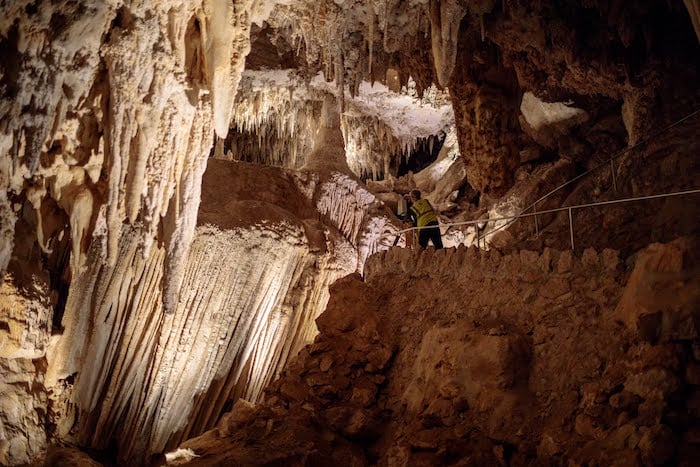
University of Arkansas researchers are using laser imaging to create a highly accurate, three-dimensional, digital map of public trails inside Carlsbad Cavern, the namesake cave of Carlsbad Caverns National Park, New Mexico.
The mapping project, coupled with an intensively researched history of the cave system’s manmade infrastructure and cultural interactions, will serve as a guide for the National Park Service as it manages both natural and developed environments in the caves. The work may also be used to earn Carlsbad Cavern a listing on the National Register of Historic Places.
The university’s Center for Advanced Spatial Technologies, or CAST, is performing the mapping project using a light-detection and ranging tool, or LiDAR, the same technology it employed to scan the Great Pyramid of Giza in Egypt, St. Paul’s Cathedral in London, and the largest building in the ancient city of Petra, Jordan, among other projects. CAST was chosen because of its expertise in this remote sensing technology, which uses a pulsed laser to collect billions of measurements of a physical space in 3-D. The measurements form a “point cloud” used to digitally recreate the space, providing insights into how it was built and what changes have been made.
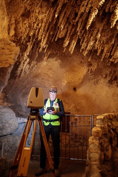
Malcolm Williamson, a research associate with CAST, said experience gained through mapping about a mile of Blanchard Springs Caverns near Mountain View, Arkansas, helped land the contract with the National Park Service. “We did that in anticipation of infrastructure improvements, and it gave us a pretty good idea of how this will go,” Williamson said.
Charting A Century Of Changes
Kimball Erdman, associate professor in the Department of Landscape Architecture, will lead the team researching and writing the report on Carlsbad Cavern’s modern history, from the first staircase installed to make the site accessible to tourists in 1925, to the cafeteria 750 feet below the surface, to naming natural features. They’ll create a Cultural Landscape Inventory, a document the National Park Service keeps for many of its properties.
“We’re looking at the ways in which humans have interacted with this environment in the past 100 years,” said Erdman. “With this the National Park Service can take the next steps for restoration, rehabilitation, or whatever needs to be done.”
Erdman has done similar work for the National Park Service in the past, documenting Arkansas sites in the Rush Historic District of the Buffalo National River, the Gypsy Camp in Siloam Springs and the Rohwer Relocation Center Memorial Cemetery in Rohwer.
“This has been the focus of my research for eight and one-half years,” Erdman said, “but I personally have never been involved in a subterranean landscape before. This is a first.”
Carlsbad Caverns National Park receives about 500,000 visitors annually, and has almost 200 miles of mapped caves, most of which are not open to the public. Researchers will begin by scanning everything visible from 3.5 miles of developed trail inside Carlsbad Cavern, including the Big Room, an 8.2-acre space that is the largest publicly accessible cave chamber in North America. They are making three 10-day visits in January and February, and will complete mapping by early 2019. Erdman’s team will begin its research in February, then spend a week doing field work along the 3.5-mile trail in the summer.
The research is supported by two National Park Service grants: $96,500 for the digital mapping and $85,900 for the Cultural Landscape Inventory.
Stories about:
Story Categories:
A copy of National Parks Traveler's financial statements may be obtained by sending a stamped, self-addressed envelope to: National Parks Traveler, P.O. Box 980452, Park City, Utah 84098. National Parks Traveler was formed in the state of Utah for the purpose of informing and educating about national parks and protected areas.
Residents of the following states may obtain a copy of our financial and additional information as stated below:
- Florida: A COPY OF THE OFFICIAL REGISTRATION AND FINANCIAL INFORMATION FOR NATIONAL PARKS TRAVELER, (REGISTRATION NO. CH 51659), MAY BE OBTAINED FROM THE DIVISION OF CONSUMER SERVICES BY CALLING 800-435-7352 OR VISITING THEIR WEBSITE. REGISTRATION DOES NOT IMPLY ENDORSEMENT, APPROVAL, OR RECOMMENDATION BY THE STATE.
- Georgia: A full and fair description of the programs and financial statement summary of National Parks Traveler is available upon request at the office and phone number indicated above.
- Maryland: Documents and information submitted under the Maryland Solicitations Act are also available, for the cost of postage and copies, from the Secretary of State, State House, Annapolis, MD 21401 (410-974-5534).
- North Carolina: Financial information about this organization and a copy of its license are available from the State Solicitation Licensing Branch at 888-830-4989 or 919-807-2214. The license is not an endorsement by the State.
- Pennsylvania: The official registration and financial information of National Parks Traveler may be obtained from the Pennsylvania Department of State by calling 800-732-0999. Registration does not imply endorsement.
- Virginia: Financial statements are available from the Virginia Department of Agriculture and Consumer Services, 102 Governor Street, Richmond, Virginia 23219.
- Washington: National Parks Traveler is registered with Washington State’s Charities Program as required by law and additional information is available by calling 800-332-4483 or visiting www.sos.wa.gov/charities, or on file at Charities Division, Office of the Secretary of State, State of Washington, Olympia, WA 98504.
INN Member

The easiest way to explore RV-friendly National Park campgrounds.

Here’s the definitive guide to National Park System campgrounds where RVers can park their rigs.
Our app is packed with RVing- specific details on more than 250 campgrounds in more than 70 national parks.
You’ll also find stories about RVing in the parks, tips helpful if you’ve just recently become an RVer, and useful planning suggestions.

Comments
This sounds pretty cool! When I was getting my undergrad degree in geology, I spent quite a bit of time helping to map the caves in the karst area of Murray, Kentucky (eons ago). All we had to work with were carbide lamps, compasses and rulers (for later number crunching) and waterproof paper on which to draw our "bird's eye view" of the passages we explored. It's hard but interesting work, and with the latest technical advances for cave mapping, it's even more interesting, now.