
A nearly impenetrable silence fills much of the 87,500-acre mosaic of forests, mountains, and streams in Maine’s sole national monument: Katahdin Woods and Waters. But as visitors hike deeper into the woods, the landscape and its denizens begin to sing. Travelers can hear the scurrying of squirrels, the buzz of dragonflies, the melodious duet of mating songbirds, the gush of brooks, and the occasional bellowing of moose.
“This is a landscape that its beauty and its importance are subtle,” said Lucas St. Clair, president of Elliotsville Foundation Inc., which donated the land that became the monument. “The more you spend time in it, the more it reveals its beauty.”
While Katahdin Woods and Waters was established by President Barack Obama in 2016, the land within it has an ancient legacy. For more than 10,000 years, the Citizens of the Penobscot Nation relied on it and the surrounding areas for fur, food, and medicine. They paddled through and fished sections of the nearly 8,600-square-mile Penobscot River and its tributaries in which the monument falls. It’s part of their ancestral homeland.
Old dirt logging roads connect today's explorers to trails and picnic areas, although some are still used by companies for transporting goods. They are following in the footprints of many naturalists, artists, writers, and explorers who traversed its landscape through the centuries.

An interior view of the soon-to-open visitor center/James Florio
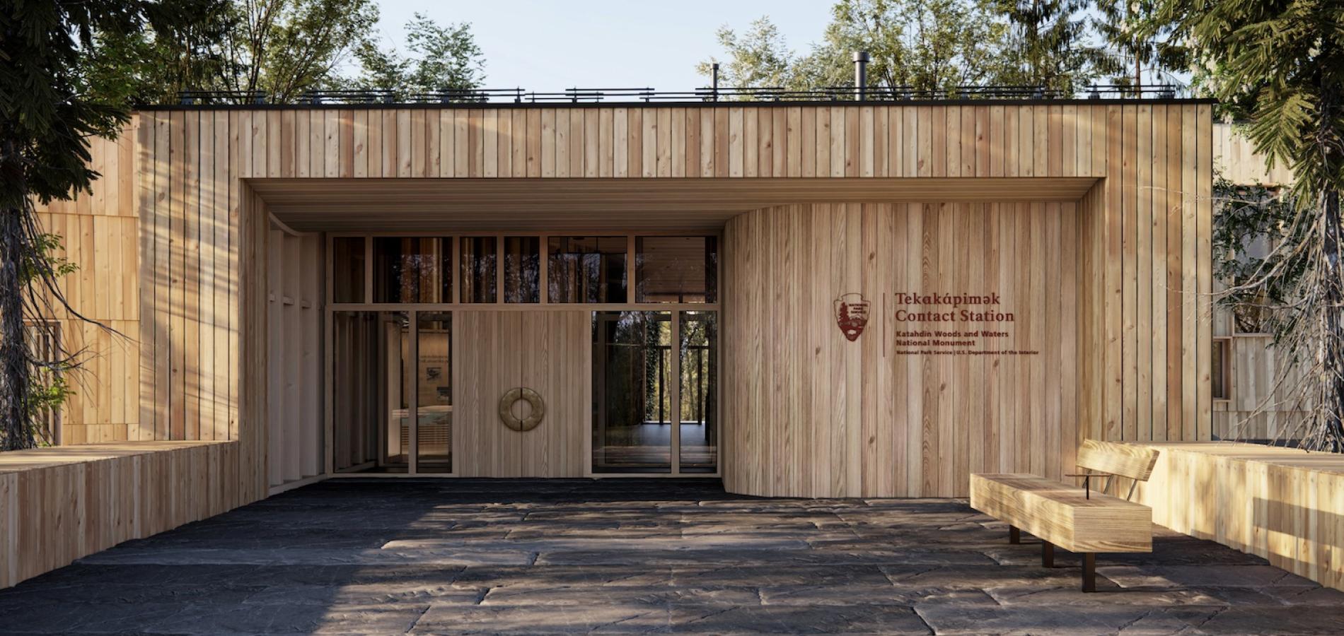
As a relatively new national monument, resources that attract visitors to Katahdin Woods and Waters and educate them on how to safely navigate it are minimal. To bolster accessibility to and excitement for the monument, the Elliotsville Foundation launched the development of a new visitors’ center — one with unique architecture that harmonizes with the landscape and showcases its rich history. After five years of planning, fundraising, and construction, the Tekαkαpimək Contact Station will be finished and open later this year.
The development of Tekαkαpimək was conducted in consultation with the National Park Service, and supported by the Friends of Katahdin Woods and Waters, the official philanthropic partner for the monument. One of its key objectives is to highlight knowledge, culture and stories of the citizens of the Wabanaki Nations in Maine, which include the Penobscot Nation, Passamaquoddy Nation, Mi’kmaq Nation and Houlton Band of Maliseets. As a result, the foundation co-created the facility with artists, historians and other experts who make up the Wabanaki Advisory Board. Penobscot Nation Chief Kirk E. Francis could not be reached for comment.

East Branch of the Penobscot River/Mark Picard
“I’d seen it at a lot of other National Parks where I’d see the story of Indigenous people and Native Nations would be left out,” St. Clair said, “so when we started thinking out the interpretive aspects of this place, we knew we’d want to have Wabanaki stories be told. That we wanted visitors to experience and understand an Indigenous worldview, and that would be the most important thing we could do while building infrastructure.”
The foundation co-created the facility with artists, historians, and other experts who make up the Wabanaki Advisory Board.
“There were so many ways the respect for this place and the natural world has been incorporated into the design (of Tekαkαpimək),” said Jennifer Neptune, a Penobscot artist and writer Wabanaki Advisory Board member who could not be reached for comment, in a promotional video for Tekαkαpimək. “A lot of the time, the story of the North Woods has started with the logging industry, but it’s so much richer and deeper than that.”
Celebrating The Landscape
Tekαkαpimək is a Penobscot word that translates to “as far as one can see.” The contact station is located about three miles up a gravel road that climbs towards the peak of the 804-foot-tall Lookout Mountain in the southern portion of the monument. Upon its completion, it will be given to Park Service to manage, St. Clair said.
Mark Wimmer, who works for Park Service as the monument’s superintendent, could not comment in time for this article.
The 7,900-square-foot contact station has an angular, undefined shape consisting primarily of rectangular faces, and rises nearly as tall as the surrounding pines. The milled cedar exterior frames numerous windows, the tallest of which are adorned in white dots to deter birds. Outside the station is an eastern outlook and small network of accessible gravel pathways so people who experience limited mobility can explore the area.
The interior of Tekαkαpimək, made of Douglas fir wood, features numerous exhibits with illustrations, old photographs, sculptures, carvings, descriptive text, quotes and even poetry inspired by the landscape.
Laser engraved across the concrete floor is an illustration of the entire Penobscot River Watershed with landmarks, place names and portage routes, all based on a drawing by James E. Francis Sr., a Wabanaki Advisory Board member and director of cultural and historic preservation for the Penobscot Nation. Several attempts to reach Francis were unsuccessful.
Once the facility is completed, it also will feature clay tiles with designs that reflect different aspects of Wabanaki culture, according to the Elliotsville Foundation. Creating clay ceramics is a tradition that has faded into obscurity over the years. In another promotional video, several citizens from across the Wabanaki Nations in Maine describe using the clay tile project for Tekαkαpimək as an opportunity to reintroduce the practice, particularly among youth.
“We decided, along with the Wabanaki Advisory Board that assisted in the project, that using clay and working with Wabanaki youth would be a really important way to revitalize this really important artistic form and use it in storytelling,” St. Clair said. “Throughout that process, a number of people became really interested and excited about making things from clay, and now it’s something that’s being done beyond the visitors contact station.”
Exploring A Monumental Legacy

The center rises to the roof the forest canopy/Mir
Entering the center, visitors will be greeted by a welcome area with exhibits that provide an overview of the monument and its cultural and natural history. There also will be an information desk staffed by NPS rangers to provide the weather forecast, stream levels, directions, maps, trail and parking information, and answer questions. Already in place covering one of the walls and ceiling above the desk is a patchwork of square pieces of new and weather-treated copper hand-woven together by Passamaquoddy basketmaker Gabriel Frey and other Wabanaki artists.
Beyond the welcome area in the South Wing are exhibits about the Penobscot River Watershed. There are displays about birch bark canoes, how to read the river, and various wildlife and their names translated in different Wabanaki languages. There is also an exhibit on the lifecycle of Atlantic salmon, complete with painted 3D printed models.
Brian Hinrichs, executive director of Friends of Katahdin Woods and Waters, said the exhibits tell a powerful story that allows visitors to “leave with an understanding of how the Penobscot River has been the lifeblood of the Penobscot Nation.”
The West Wing's exhibits highlight the geology of the monument and surrounding region. Rocky ridges, or eskers, and large boulders, or erratics, across the monument depict the paths taken by glaciers as they receded at the end of the last ice age, according to NPS. Other geologic features include granite remains from a supervolcano eruption that occurred about 407 million years ago and fossils indicating that a portion of the monument once was a coral reef.
Connected to the West Wing is an outdoor outlook with a view of Mount Katahdin — the tallest mountain in Maine at 5,269 feet and the northern terminus of the Appalachian Trail. Katahdin translates to “Greatest Mountain” in Penobscot, and it holds cultural significance for all Wabanaki Nations in Maine. Along the wood and glass railing of the outlook is a display about the mountain, including translations of its name in other Wabanaki languages.
The North Wing highlights the International Dark Sky Sanctuary designation the monument earned in 2020. With no artificial lighting or commercial power supply, the sky above the monument is among the darkest east of the Mississippi River, according to NPS.
One display in the wing educates visitors on how the dark sky helps nocturnal animals navigate their environment. Another showcases the Wabanaki constellations and the mythology behind them through a wheel that visitors can turn to reveal which ones are visible in each season.
A first look celebration for Tekαkαpimək is scheduled to held from 2 p.m.-5 p.m. on Saturday, August 17, and again from 10 a.m.-4 p.m. on Sunday, August 18. Registration is required and can be done online. Consistent hours of operation for the station following the event will be established at a later date.
“When this land was donated and became a national monument, in the presidential proclamation, President Obama highlighted all the natural and cultural wonders of this land,” Hinrichs said. “I firmly believe that this project, Tekαkαpimək, captures both the natural and cultural resources that we are protecting so beautifully.”


Comments
Beautiful article. So proud of my son. I can't wait too visit and learn more about the history of this State Park that Marcus loves.
Very in depth and wonderful article!