Editor's note: Yellowstone Caldera Chronicles is a weekly column written by scientists and collaborators of the Yellowstone Volcano Observatory. This week's contribution is from Jamie Farrell, associate research professor with the University of Utah Seismograph Stations and Chief Seismologist of the Yellowstone Volcano Observatory.
The Yellowstone Seismic Network is designed to record ground shaking due to earthquakes. But earthquakes aren’t the only things that rattle the ground in Yellowstone!
It is well-known that the Yellowstone region, with an average of 1,500-2,500 earthquakes per year, is one of the most-seismically active areas in the western U.S. The Yellowstone Seismic Network is designed to record the ground shaking from these earthquakes and send the data back to the University of Utah in real time for analysis. There are a lot of other things that cause the ground to shake, however, and this shaking is recorded by seismic stations in and around Yellowstone. Most of the time, it is easy to differentiate these signals from those of real earthquakes.
So, what else besides earthquakes makes the ground shake in Yellowstone?

Webicorders of Yellowstone Seismic Network stations YMR (West Entrance road) and YNM (Norris Geyser Basin Museum) showing traffic signals (left) and visitors walking (right) during daytime hours. Both records span the entire 24-hour period of July 23, 2024, MDT.
Some of the most common causes of non-earthquake ground shaking are humans and the vehicles that they drive. As a general guideline, seismic stations are located far away from roads to avoid these signals, but there are some that are close enough to record every car/truck/bus/RV that drives by. A seismic station that is located near the Madison-West Entrance Road, designated YMR, is notorious for recording road noise. In addition, a seismic station that is located in the Norris Geyser Basin Museum (designated YNM) records the thousands of visitors that walk by it every day during the summer. Signals that are related to human activity can be identified by their prevalence during the daytime hours and their absence during nighttime hours.
Signals related to non-earthquake geologic events far from Yellowstone can sometimes be seen as well. An example of this is the 2022 Hunga Tonga–Hunga Haʻapai volcanic eruption in the south Pacific. The volcano is located about 9,742 km (6,053 miles) from Yellowstone National Park, but the signals from that violent eruption are clearly seen on many stations in the Yellowstone Seismic Network. In fact, that eruption produced two signals that are evident in the Yellowstone seismic record. The first signal is the direct P-wave (seismic phase) that traveled through the earth from the eruption site to Yellowstone—the wave arrived ~27 minutes after the eruption occurred. The eruption also produced very powerful atmospheric waves. The most energetic of these atmospheric waves was something called a Lamb wave, which travelled through the atmosphere but along the Earth’s surface. The Lamb waves from the eruption traveled around the earth 4 times over 6 days. The first of these arrived in Yellowstone ~9 hours after the eruption—moving at the speed of sound, which is much slower than the speed of earthquake waves through the ground—and is evident on both seismometers and infrasound microphones. This shows that as the Lamb wave propagated along the Earth’s surface, not only did it cause an atmospheric disturbance (as recorded by the infrasound microphone) but energy was also transferred into the Earth (as recorded by the seismometer). In this sense, the wave was similar to a sonic boom or thunderclap.
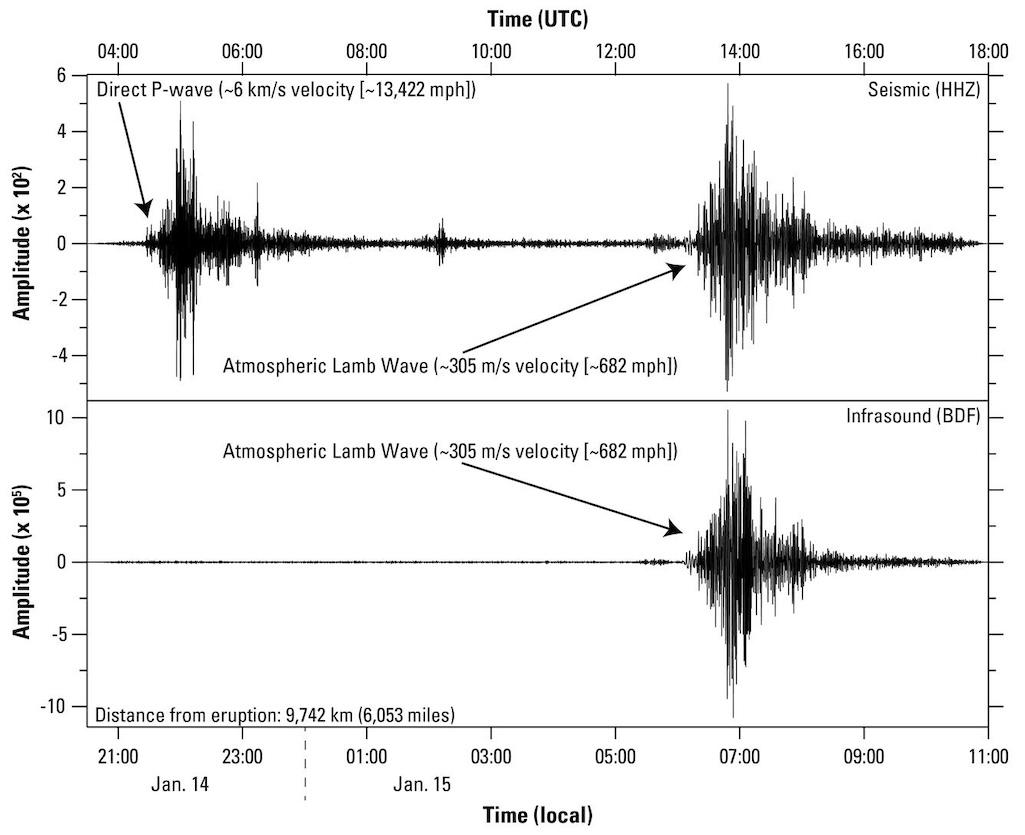
Signals recorded at station YDD in Yellowstone National Park from the 2022 Hunga Tonga–Hunga Haʻapai volcanic eruption. The seismometer at YDD recorded both the direct seismic phase (top left) as well as the atmospheric Lamb Wave that coupled to the ground as it propagated (top right). The infrasound microphone at YDD recorded the atmospheric disturbance from the Lamb wave (bottom right) that arrived in Yellowstone ~9 hours after the eruption. Seismic waves travel through the earth much faster than sound waves travel through the atmosphere, which explains the long delay in timing between when the two signals were recorded.
Other non-earthquake signals are sometimes recorded on seismometers around rivers due to ground shaking from large floods in Yellowstone, like those that occurred in June 2022. Near Yellowstone Lake, seismometers record “icequakes” from cracking of the ice cover during winter, and when the lake is free of ice during summer months ground shaking can be caused by wave action on the lake during daytime hours. In addition, seismometers record signals related to hydrothermal activity and even hydrothermal explosions.
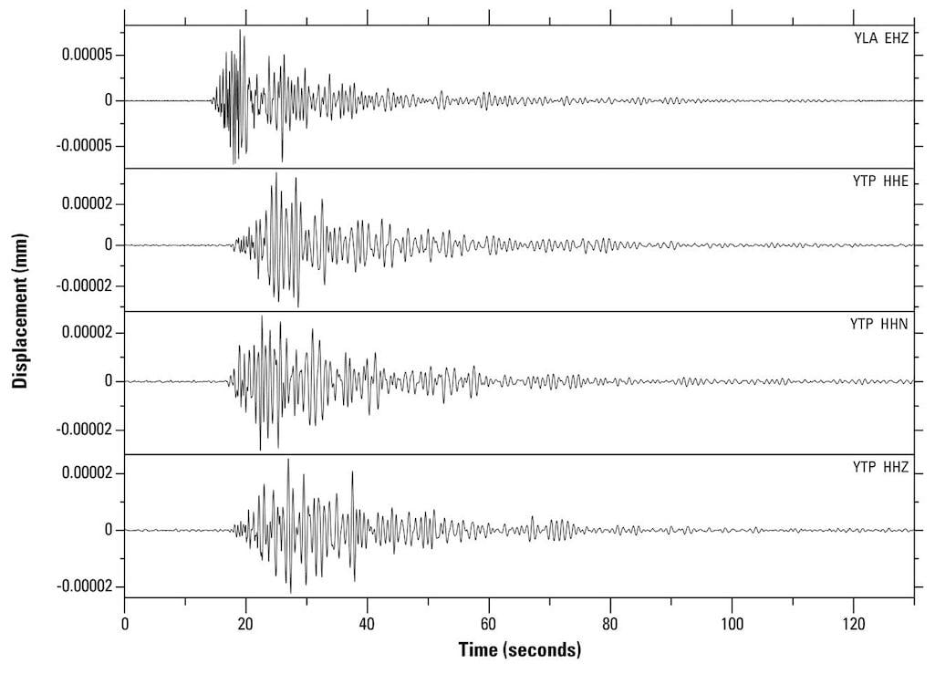
Signals from a suspected icequake that occurred on Yellowstone Lake recorded at Yellowstone Seismic Network stations YLA on Lake Butte (top) and YTP at The Promontory (bottom 3 plots). Plot shows about 2 minutes of data from January 24, 2022, starting at about 7:43:34 p.m. MST. YLA waveform (YLA EHZ) was recorded on a vertical short-period sensor. YTP waveforms were recorded by a broadband sensor, including east-west (YTP HHE), north-south (YTP HHN) and vertical (YTP HHZ) components.
Even though these non-earthquake signals are not what the Yellowstone Seismic Network was originally designed to record, they still provide valuable insights into the Yellowstone volcanic and tectonic system. Scientists are increasingly using these data to better understand the dynamic nature of geologic activity in the Yellowstone region.


