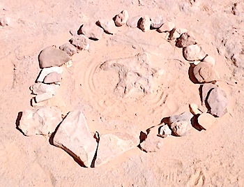
Dinosaur tracks millions of years old can be tough to discern from ripples in sandstone, so it seems only natural to ask how to tell the real thing from fickle currents in the rock floor of Horseshoe Canyon in Canyonlands National Park.
"If there's a ring of rocks around it (it's a track)," Ranger Nicole Loiseau joked as we headed towards the "Great Gallery," a collection of paintings ancient cultures left thousands of years ago.
The gallery is the highlight of the roughly 7-mile roundtrip hike, but not the only aspect. There are at least three fossilized dinosaur tracks, according to those who can discern tracks from ripples, vestiges of early energy exploration and mid-20th century ranching operations, several other rock art panels, and the simple beauty of a deep, cottonwood-lined wash cut through the Colorado Plateau.
The Main Attraction
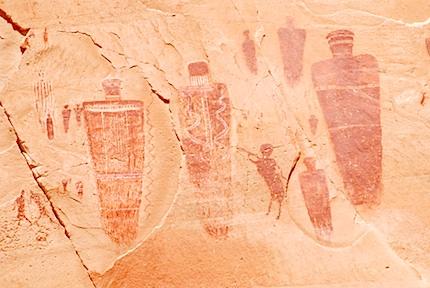
But there's no question the Great Gallery is the main draw, and for justifiable reasons. In a region -- the Colorado Plateau -- with staggering and impressive amounts of rock art, this gallery is the grail. The age of the panel alone is wondrous in that it has survived the elements and erosion, and avoided, mostly, the simple collapse of its canvas for tens of centuries. Exactly how many thousands of years ago it was painted is up for speculation. Some archaeologists who have studied the Barrier Canyon images believe they were created by Archaic age shamans between 1900 B.C.and A.D.300.

Known dinosaur tracks in Horseshoe Canyon are ringed by rocks. Marcelle Shoop photo.
Alan Watchman, a research fellow at Australian National University, says radiocarbon analysis dates some of them to the Early Archaic period, from about 7430 B.C.to 5260 B.C. -- or more than 9,000 years ago.
What is not so speculative is the wonder you come away with from gazing at these petroglyphs and pictographs pecked and painted onto the sandstone walls. The “Holy Ghost,” a towering, armless anthropomorph with either a huge head or turban atop its shoulders, is the focal point of the gallery. What was the significance of his striped robe, his entourage, his size relative to the others?
As your eyes wander this vast mural some 300 feet long and featuring about 80 figures, you can make out flitting birds, bighorn sheep, and even dogs, along with bizarre, life-size figurines. As a whole, this panel would deservedly dominate a room in the Smithsonian Institution. But that it exists here, on its original plein air sandstone palette, where only 8,000-10,000 people see it a year, is entirely more fitting.
Even today this setting is revealing parts of its past. During a 2005 visit some visitors discovered leather pouches filled with seeds and stone tools, a time capsule of sorts that could be 1,100 years old.
A Once-In-A-Lifetime Experience
A visit to the gallery likely is a once-in-a-lifetime experience for most people. That's because the wash is in the Horseshoe Canyon annex of Canyonlands. To get there you have to drive at least 30 miles along a dirt road from Utah 24 to the trailhead, where you find a small, unadorned flat spot at the edge of a cliff where you can pitch a tent to spend the night before, or after, your hike to the gallery.
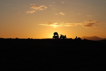
For newcomers to the Southwest the drive can be mesmerizing, as your windshield frames sagebrush covered landscapes interrupted occasionally by buttes soaring into the sky. In a few places ruddy sand dunes ripple across not just this landscape, but also the road, one of the reasons it's not a bad idea of have a four-wheel, or all-wheel, drive vehicle with reasonable ground clearance....and a spare tire and full tank of gas.

Summer hikes of Horseshoe Canyon can start early to avoid the high heat of the day. Kurt Repanshek photo.
The trailhead offers, in addition to the flat spots to pitch your tent, a one-seater vault toilet, and a small kiosk with information on the canyon, its artworks, and cautions about how much water you should take with you (one gallon per person is recommended, and you need to bring your own, as there's no water here).
From here you enjoy sweeping views out across the rumpled landscape that eons ago was one of the large sand dune complexes on the continent. Today those dunes have been fossilized into sandstone that in turn have been cut by erosion.
For a few months in spring rangers show up on weekends (some years Saturdays and Sundays, this year just Saturdays running through May 25) to lead hikers to the gallery and provide insights to both the landscape and the artists.
My wife and I lucked out, as Ranger Loiseau had arrived on the Saturday before Easter to lead any interested parties down, and with no others in sight and the 9 a.m. start time behind us, the three of us headed down the trail.
The Hike And The History
The ranger recounted the days of early oil exploration in the region that led to the chiseling of a road through the sandstone down from the cliff top to the wash floor, and then up the other side of the canyon to allow for exploration. While the exploration failed to turn up any developable resources, today visitors benefit from the road by using it to hike down into the wash to view the rock art, and vestiges of its route can clearly be seen on the opposite cliff face.
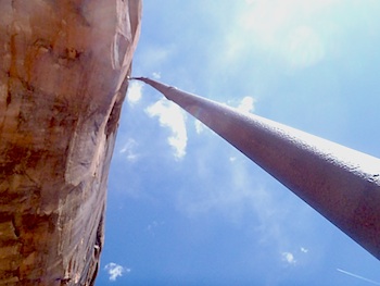
Along with pointing the first of three dinosaur tracks we would come upon, Ranger Loiseau talked about the peregrine falcons that nest in the canyon, and the ranching industry that grazed sheep and built elaborate piping systems to suck water up from the wash floor to fill water tanks and troughs on the canyon rim. That piping system remains in place today and is something of a wonder when you look at it snaking straight up a cliff face.
Along the way to the Great Gallery we wandered from the High Gallery to the Shelter Site and then the Alcove Site, three collections of alluring rock art that kickstart your imagination. What do the figures represent, how where they created, and how have they imagined to survive the passing centuries?

Mid-20th Century ranchers ran a pipeline straight up the canyon walls to provide water for livestock. Kurt Repanshek photo.
Leading us through loose sand that taxes your calves, along sand compacted by the scant moisture that runs in place through the wash, and through cottonwood stands the ranger took us deeper and deeper into Horseshoe Canyon until we were standing before the Great Gallery. It was readily apparent that all that came before was merely an appetizer for this moment.
The hike is mostly easy, starting with a downhill pitch and then following a flat, sandy wash bottom. The only real hard part is the returning to your car, as that downhill pitch you started off on is now an uphill trudge that ascends 750-800 feet in switchbacks. That last section might not sound like much, but in late spring or the heart of summer, the canyon can turn into an oven of sorts with temperatures approaching 100, so pack plenty of water and sunblock, and take your time. Five hours is not an unreasonable amount of time spent in the canyon.
For more information on the archaeology of Horseshoe Canyon and the surrounding Colorado Plateau, explore this collection of writings.


 Support Essential Coverage of Essential Places


Comments
My visit to Horseshoe Canyon was one of the most memorable of anything I've done. I went out via a graded dirt road running south from Green River. Along the way I had met one pickup and a road grader in something like fifty miles.
Once I got there I found myself completely alone. An awesome experience. The panels are a true treasure. With no ranger to guide me, I missed the dinosaur tracks. The pipeline is in itself a real testimony to the determination and hard work of people who were struggling to make a living from this land. It was almost as awesome as the panel. The fact that the panel is so well preserved tells us something of the remoteness of the canyon. There were hardly any bullet holes in the figures.
When I came up out of the canyon, storm clouds were moving in. I headed west toward Goblin Valley State Park. Along that thirty mile route, I met a huge NPS water tanker hauling water to Hans Flat ranger station and then encountered two women in a sedan who had made the long trip to Hans Flat. By that time it was pouring rain and the road was becoming very muddy so I stayed with them to make sure they made it to pavement. Had to hook up twice and pull them from mud holes. The night at Goblin Valley was filled with drenching rain and flashing thunder. A very impressive storm even by our standards. The next morning, I discovered that the highway between Hanksville and Capitol Reef had washed out in a couple of places. The school bus filled with kids from Hanksville as they made their forty five mile daily trip home from school was stranded. Fortunately, they were right beside the only motel along the way and were able to hole up there.
Anyone thinking to visit the canyon must be very careful to follow Kurt's advice and be totally prepared for anything. It might be an awfully long wait for help.
Excellent article! Horseshoe Canyon is the holy grail for pictographs in my opinion! You covered all the bases here! We drove in a regular car, got a little nervous driving through the deep sand, but we made it! Went in July at 102 degrees(not recommended) but, you have to go when you can to this fantastic place!