It was a stellar blue-skies mid-summer day, and a nice on-shore breeze from the Atlantic made the temperature just about perfect at noon. A short stroll from the road via a section of boardwalk had led me to a prime spot on a rocky outcropping not far above the ocean, where the sound of the waves breaking on the rugged shoreline almost drowned out the raucous cries of gulls circling overhead.
This spot, where a jumble of enormous boulders and water-carved stony platforms juts into the sea, is known as Lakie Head, and it's reported to be a good place to look for whales just offshore.
A middle-aged couple had arrived before I did and were peering intently toward the water through binoculars.
"There!" Did you see that one?" the man asked excitedly.
"Yeah, amazing!" his companion replied.
I looked carefully in same general area, but didn't spot anything noteworthy. "Whales?" I asked.
The man lowered his binocs and smiled. "Nope, we call 'em dive-bomber birds. Just watch for the splash!"
I looked harder in the area where he pointed, and sure enough, a few seconds later spotted a brief mini-geyser. A closer look revealed a flock of large white birds circling perhaps a hundred feet above the water. At intervals, one would suddenly become a vertical torpedo; hitting the water at terrific speed and disappearing completely from sight, it would resurface a few seconds later, presumably with a fish on board.
It was quite a show, and an interpretive sign nearby identified these fish-catching daredevils as Northern Gannets. You can see some beautiful footage of gannets on action at this link; you may want to use the "slider" at the bottom of the video image to skip ahead to the 1:30 point on the video for the dive-bombing action.
Canada's Great Scenery Isn't Limited to the Western National Parks
Lakie Head is just one of many fine spots where you can enjoy the outstanding scenery in Cape Breton Highlands National Park, but that's an area that may not be familiar to a lot of park fans from the U. S. A. If you mention "Canadian National Parks" to travel buffs, that nation's spectacular western sites such as Banff and Jasper National Parks will likely come to mind. There are, however, some worthy candidates for your "gotta plan a trip" list on the opposite side of the county in Canada's Maritime Provinces.
The "Canadian Maritimes" are generally defined as the provinces of Nova Scotia, New Brunswick and Prince Edward Island, the section of Canada that lies along the Atlantic coast just north of Maine. Many Americans have a pretty fuzzy mental picture of the geography in this area, so the map at this link will give you a quick overview.
Over the next several weeks the Traveler will offer up a sampler of some of the best that Parks Canada has to offer in the Maritimes, and we'll begin with an area that makes plenty of "must see" lists of great scenic drives in North America: the Cabot Trail and Cape Breton Highlands National Park.
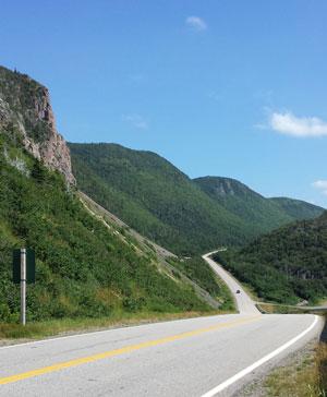
The Cabot Trail is actually a modern paved highway. Jim Burnett photo.
This "Trail" is for Driving or Biking
Don't be misled by the term "trail"; this nearly 300-kilometer (185-mile) drive is a modern paved highway which winds a spectacular and serpentine route across the northern part of Nova Scotia's Cape Breton Island. This island is a sizeable one, about 150 miles long north to south, and 95 miles east to west.
About one-third of the Cabot Trail is located within the borders of Cape Breton Highlands National Park, whose 234,000 acres include one of the largest protected natural areas in the Maritimes.
According to the park website, the area includes "spectacular highlands and ocean scenery, steep cliffs and deep river canyons carved into a forested plateau bordering the Atlantic Ocean... The cool maritime climate and rugged landscape results in a unique blend of Acadian, Boreal and Taiga habitats, plants and animals, a special mix of northern and southern species not found anywhere else in Canada."
Crowds and Traffic Were Not a Problem
I found all that, and plenty more, during a visit in mid-July. If you'd like a one-sentence comparison of this park to a similar site in the U. S. A., it might be: Acadia National Park ....with smaller crowds and less traffic during the peak summer season.
Cape Breton Highlands National Park has something to offer almost any park aficionado, whether you enjoy hiking, biking, wildlife watching, scenic driving, photography, camping, fishing or even spending some time on the beach. Even though these waters are part of the North Atlantic, the park includes several developed swim beaches on both salt and fresh water where the water in July seemed to be warm enough for swimming'at least by local standards.
The water may be inviting, but the big draw for this park, at least for visitors from afar, is the scenery along the Cabot Trail. Depending upon your other travel plans in the Maritimes, you can drive the entire 185-mile loop, or skip the southern section of the drive that bisects the interior of the island. This interactive map will provide a general overview of the Trail and points of interest, both inside and outside the park.
Which Direction to Drive the Loop?
Your main decision will be to choose one of two points to enter the park along the drive, and that will determine your direction of travel around the loop: clockwise (beginning on the western side of the island near the community of Cheticamp) or counterclockwise (beginning on the eastern side in the Ingonish area.)
The scenery will be the same, of course, although the perspective and lighting will be a bit different, so my suggestion is to base your decision on which one fits best into your overall trip plans. Once you start the drive, you're committed to either complete it, or turn around and retrace your route; there are no roads through the center of the park connecting the east and west sides of Cape Breton Island.
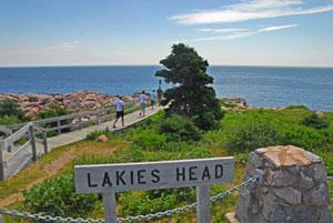
Short trails like the one at Lakies Head get you close to the water and the view. Jim Burnett photo.
We chose to make the counterclockwise loop, beginning on the east in the Ingonish area; that kept us on the "ocean side" rather than the "interior side" of the road, which offered slightly better views for the person in the passenger seat.
Look Out for Look-Offs
No matter which direction of travel you choose, there are a number of "look-offs" (the local word for "overlooks") where you can pull over and the driver can enjoy the scenery as well. In many cases, those look-offs also offer interpretive signs with helpful information, so almost all are worth at least a brief stop.
So, where's the best scenery along the Cabot Trail?
That's akin to asking if you want your ice cream in a cone or a dish, so the answer depends partly on what you enjoy seeing and doing. For planning purposes, however, you can divide the drive into three general sections. A copy of the park map is available here, and may be useful in getting your bearings.
Highlights of the Cabot Trail
The eastern section, from Ingonish Beach north to Neil's Harbor, covers less than 20 miles of road, but don't rush. This part of the Trail hugs the Atlantic coast and offers some fine views from look-offs and rocky headlands, and also includes most of the beach access in the park. If you're want to get close to the water, this section of the Trail is the best choice.
If you begin your trip in the Ingonish Beach area, the Cabot Trail enters and then leaves the park for several miles before returning to the park once again, so don't be dismayed by the scattered private development along the road during the first few miles of your trip.
The middle section of the Cabot Trail runs across the northern edge of the park between Neil's Harbor and Pleasant Bay, and covers about 30 miles of inland forested highland terrain. The only significant "water views" along this stretch occur briefly in the South Harbor area, where you can take a side trip out of the park to the far northern end of the island.
You'll find a combination of the first two sections on the third leg of the Trail between Pleasant Bay and Cheticamp. This section of the Trail covers about 30 miles, partly along the coast of the Bay of St. Lawrence and partly through inland highlands. It includes the most dramatic terrain in terms of highest mountains, deepest valleys and steepest grades, and the view of the road as it runs south from the Veterans Monument look-off is likely one of the most photographed scenes in the park.
This Drive Deserves Days, Not Hours
If you're a math whiz and have been keeping track of the mileage, you've noticed that the total distance for this drive through the park is less than 80 miles, and according to the cyber-wizards at Google Maps, you could drive that entire route non-stop in a couple of hours. Doing so would be a shame, however, and depending upon how much you want to see and do, you could easily spend several days sampling this park's offerings.
To help you get started on your travel planning, here are a few highlights gleaned from my trip last month.
Hikes. The park website lists 26 named trails that "range from easy strolls to challenging climbs with panoramic views of canyons, highlands and seacoasts." A handy map at this link helps you locate them all; click on the trail's name for a description of each route.
We quickly gleaned one useful tip about the trail descriptions on the park website: The information listed for "elevation" (such as "15 to 150 feet" for the Middle Head Trail) is the range of elevation above sea level from highest to lowest you'll encounter along that trail. It has no relationship to the number of times you'll gain, lose and regain those same 135 feet in the course of some of these hikes!
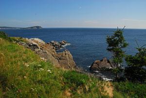
The hike to the end of Middle Head rewards you with some lovely views. Jim Burnett photo..
Based on a recommendation at the park information station, we hiked the Middle Head Trail in the southeastern section of the park. From late June until late August, a park naturalist leads a guided hike at 10 a.m. each morning on this 2.4 mile-round trip, which "follows a long, narrow peninsula separating two ocean bays, ending on headland cliffs overlooking the Atlantic Ocean, Cape Smokey and Ingonish Island."
We opted to get an earlier start, and as a result had the trail virtually to ourselves during the outbound trip, even on a lovely Saturday morning in mid-July. We met the guided trip and other hikers headed in as we returned to the trailhead, but at no time did the trail ever seem crowded.
This is a nice route with some fine views, especially near the mid-point and at the end, but I'd say the description as "mostly level with short climbs, some rocky, rugged sections," is a little optimistic, especially if you include the loop on the western half of the route. That part of the trail includes some rocky and uneven footing with a lot of up-and-down terrain, offering relatively little in the way of views.
My advice for this trip is to take the "main" route (see the map at this link) both in and out, and skip the loop for a much more enjoyable hike. As you begin the hike, just keep right at the first fork and proceed past the sign about coyotes. The views from the rocky headlands at the end of the trail are spectacular, but take the advice of warning signs, and keep any kids'or careless adults'under control. There are no railings to interrupt the view along the top of the cliffs, which drop almost straight down to the rocky shoreline.
The View from the Top
Seasoned (and fit) hikers can enjoy an excellent view of the Ingonish, Middle Head and Cape Smokey areas on the park's east side from the top of Franey Mountain, but the 4.6-mile round trip requires a steep climb.
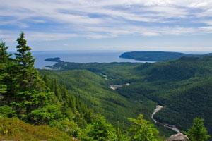
The view from Franey Mountain. Photo by Parks Canada/Chris Reardon.
One of the best combinations of dramatic vistas and a relatively easy hike is found along the Skyline Trail, located on the western side of the park. A section of boardwalk and a long series of steps end at an overlook 1,200 feet above the ocean; the views of the coast and portions of the Cabot Trail far below well deserve the term "spectacular."
As on the Middle Head hike, stay on the most direct route (4.7 miles round-trip) for a hike suitable for most skill levels. An optional "back loop" adds another mile and is reported to be more demanding.
Four evenings a week (Fridays through Mondays) during the summer you can join a guided sunset hike with a park naturalist on the Skyline Trail. The journey begins two hours before sunset, and there is a fee for this activity. See this link for details on this and other special programs in the park.
Scenic Drives. You don't have to take a hike to enjoy the scenery (although I highly recommend at least one), because the number of photo ops from the "look-offs" along the Cabot Trail are a good reason to have a digital camera'along with spare batteries and plenty of space on those memory cards. The following look-offs are especially worth a stop; they are listed counterclockwise along the Trail, driving from Ingonish toward Cheticamp.
I've already mentioned Lakies Head, which is less than a half hour's drive north of the Ingonish area. Unless the surf is up due to strong winds, another prime coastal view is available less than two miles north of Lakies Head, at Green Cove. A short (0.1 mile round trip) section of boardwalk and steps leads you onto a rocky area not far above the crashing surf.
It's not uncommon to see fishermen plying their trade just offshore, and this is another good place to look for whales. The weather was near-perfect during our visit, but do pay attention to the warnings signs during stormy seas, especially if the tide is in. You should need to stay close to the road, and off the exposed rocky bench, during heavy weather, since huge rogue waves have been known to wash over those rocks with little warning. The short video at this link offers an example of rough seas at Green Cove.
On the opposite side of the island, along the western section of the Cabot Trail, the MacKenzie Mountain Look-off offers a double feature: great views of the forested ridges and valleys of the Highlands Plateau plus a look down at the Gulf of St. Lawrence. If you have binoculars, scan the water for the tell-tale vapor from whales "spouting" near shore.
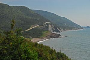
The Veterans Monument look-off offers magnificent views of the Cabot Trail.
A definite not-to-miss look-off on the western side of the drive is Veteran's Monument, so-named for a plaque that honors Canadians who died overseas during the World Wars. The view from here of the Cabot Trail, the dramatic coastline and the Gulf is post card and calendar material, and this is another good spot to look for whales. At the time we stopped, a park naturalist was on hand here to talk about whales and any other topics of interest.
You'll find descriptions of these and other key look-offs at this page on the park website, although unfortunately the numbers on the maps are not correlated with the accompanying descriptions.
What about wildlife? Signs and conversations with locals warned of the need to be alert for moose while driving on Cape Breton Island'and hiking the Skyline Trail'but we saw nary an animal larger than a squirrel during several days in the area. Birds, including several bald eagles and those dive-bombing gannets, were more in evidence, and several communities near the park offer commercial whale-watching trips during the summer.
In addition to fine scenery, Cape Breton Island has a colorful history that carries over into an interesting mix of cultures even today. You'll find MacKenzie Mountain and MacIntosh Lake on the park map, only a few miles from French Mountain and Grande Falaise, names that offer hints of the tug-of-war between the British and French over this region which began in the 1600s and continued for parts of two centuries.
The terrain is reminiscent of the Scottish Highlands, the ancestral home of many of the settlers who flocked to this area in the 18th and 19th centuries. The Gaelic culture is alive and well on Cape Breton Island, and not far outside the western entrance to the park, the French heritage is especially evident in the delightful community of Cheticamp.
After a day enjoying some superb scenery, this is a good place for a meal and an overnight stop, and it's not hard to locate some toe-tapping live music to enrich your dinner in a local restaurant. Ask around, and you'll likely locate a ceilidh (kay'-lee), an informal musical gathering with traditional Gaelic music that centers around some fine fiddling.South of the park, the province of Nova Scotia has even marked an official "Ceilidh Trail" along main highways.
Where to Stay. In addition to the town of Cheticamp on the southwest edge of the park, you'll find a scattering of lodging options in the vicinity of Pleasant Bay and South Harbor on the northern end of the Trail. You'll also find places to stay near the southeastern corner of the park, but pay close attention when you make your reservation. A half-dozen communities near the southeast corner of the park share some variation of the name "Ingonish," so it helps to know if you're looking for Ingonish Ferry, Ingonish Harbor, Ingonish Center and so on.
If you're looking for something more upscale, the Keltic Lodge Resort and Spa is located inside the park's southeastern corner, near Ingonish Beach. The Highlands Links golf course near the resort offers an 18 hole course in the park, and it is in a beautiful setting.
Campers will find a full range of options in six front-country, one backcountry and one group campground. Camping is available from mid-May to mid-October, there are sites in the developed campgrounds for tents or RVs (some with hookups) and sites can be reserved in advance through the Parks Canada reservation service.
There are two park information centers: The main park visitor center is located on the west side of the park, north of Cheticamp; it has exhibits and The Nature Bookstore, which offers books, maps, gifts and some outdoor clothing. On the east side of the park, a small information station is located just north of Ingonish Beach. There is an entrance fee for the park, and the Parks Canada annual Discovery Pass is accepted.
The operating season for Cape Breton Highlands National Park runs from mid-May to mid-October, with full services available in July and August. The Cabot Trail is open year-round, although signs in several locations indicate sections of the road may be closed at times during the winter months. You'll find plenty of information to help plan a visit on the park website, and for a good overview of the island and the park, the short video below will likely tempt you to make one more entry on your travel wishlist. http://www.pc.gc.ca/eng/pn-np/ns/cbreton/visit.aspx
If you're not traveled in Canada in recent years, you're probably not aware of the difference between a "Looney" and a "Tooney," but doing so will make a visit to our northern neighbors a bit easier. You'll find a separate article in today's Traveler with some useful tips for travel to Canada.
Next Sunday the Traveler will offer a look at Canada's version of Colonial Williamsburg and one of that country's prime historical parks'Fortress of Louisbourg National Historic Site.


 Support Essential Coverage of Essential Places


Comments
Excellent, Jim! Cape Breton, Fundy, Terra Nova, Gros Morne, and L'Anse aux Meadows are all in my Top 10 Favorite Parks Ever list. Fundy probably being #1 or close to it. Can't beat the Maritimes.
But back to Cape Breton, it was ungodly hot on my one and only visit there. We allowed a day to explore on the way back from Newfoundland. The birding wasn't great due to the heat. My list shows one gannet, nine bald eagles, a few goldfinches...and then some stragglers. The old growth sugar maple forests on the interior of the loop are worth a day's exploration themselves. There's a stop on the loop called Lone Shielding in the Grand Anse Valley that offers one of the best forest walks I've ever encountered. One other thing worth mentioning is that south of Cheticamp (away from the park) the Cabot Trail becomes predominantly Francophone, akin to Quebec or upper New Brunswick. At a couple stops I had to pull out a polite "Je ne parle pas Francais" - or something like that. Everyone on the Acadian coast speaks English, but many prefer French, so an attempt at is welcomed.
And since you mentioned Northern Gannets, some folks may be interested in a gannet post I just made. Cape St. Mary's on Newfoundland is just a short drive to North Sydney, NS from Cape Breton Highlands NP...and then a 6 to 22 hour ferry ride to Newfoundland...followed by a 90 minute to 9 hour drive, depending on how long your ferry ride was. So it's not close at all! But the journey is delightful!