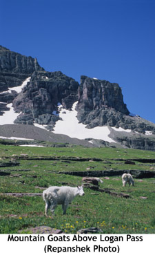
LOGAN PASS, Mont. — In this landscape defined by glaciers, mountain goats
rule. Nimble, decked out with curved black horns, professorial
goatees and thick, woolly coats, these all-terrain animals must also be a
tad egotistical. Why else would they congregate along the Hidden Lake Trail
within sight of the Logan Pass Visitor Center and pose for Glacier National
Park visitors?
I am in a small gaggle of tourists busily training our
armament of camera lenses on the goats as they grazed contentedly on the
wildflower-strewn emerald slopes. The goats are so close they could be
models strutting a runway.
Pikas, furry cat-sized rodents obviously jealous
of our focus, keep up their shrill barking to distract us, while towering
overhead are the cirques, glacial horns and snowfields that most often come
to mind when Glacier is mentioned. Nevertheless, we fill our cameras with
goats. There always will be time for scenery, but who knows what schedule
the goats follow?
Not that it matters. There’s no loss in trading scenery
for goats or vice versa in Glacier, a million-acre-plus park in northwestern
Montana nudged up against the Canadian border. Though its glaciers are
retreating — some scientists predict that, with current conditions, they
could be gone by 2030 — their absence won’t make the park any less alluring,
for its pristine lakes and forests and crags and wildlife are a breathtaking
throwback to colonial days.
Designated in 1910, almost two decades after
the Great Northern Railway brought its tracks and trains across the
relatively low 5,220-foot Marias Pass just below Glacier’s southern
boundary, Glacier tosses more ruggedness at you than just about any other
park in the Lower 48. You can see that from atop 6,664-foot Logan Pass.
The Going-to-the-Sun Road climbs up to, across, and down the pass. It’s
narrow, and at times precipitous, in a constant state of repair due to the
ravages of the freeze-thaw cycle. Beginning in 2007, park officials plan to
launch an ambitious rebuilding program intended to gain the upper hand on
both the mountainous terrain and the climate.
Logan Pass, the apex of the
Sun Road, is pinched tightly between Clements Mountain and the southern tip
of the Garden Wall, a massive rib of rock that carries the Continental
Divide through the park’s interior. From this saddle the pass sends Reynolds
Creek and Logan Creek in opposite directions as their waters cascade down
massive U-shaped valleys scooped out during the park’s glaciated past.
Farther north are the bulk of the park’s glaciers — thick sheets of ice
named “Ipasha,” “Old Sun,” “Grinnell,” “Swiftcurrent,” “Thunderbird” and
“Rainbow” — while to the south stands a maze of mountains, valleys, meadows
and backcountry lakes that it would take a lifetime to know.
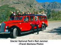
Many park
visitors motor up to the pass aboard a Red Jammer, one of Glacier’s renowned
fire engine-red, open-air touring buses that debuted in 1937 and quickly
gained their nickname for the way drivers “jammed” their way through the
gears. Along the way, they struggle to digest this complex landscape that
the Blackfoot Nation — the park’s original human inhabitants — calls the “Shining Mountains” and the “Backbone of the World.”
Here Bird Woman
Falls spills 492 feet to Logan Creek, over there on the western horizon,
ponderous Heavens Peak shimmers under streaks of its permanent snowfield,
here’s a meadow of Beargrass and Glacier lilies.
Weeping Rock showers
west-bound Jammers with icy snowmelt, while the Highline Trail shuttles
hikers, and the ubiquitous goats, 7.6 miles into the backcountry and the
Granite Park Chalet, a rustic stone-built shelter that’s a throwback to the
1910s when pack horses hauled visitors across the park.
 So massive is
the park that it’s both a sin and a miracle that only the Sun Road slices
entirely through the interior. A few shorter roads jog briefly into Glacier,
but they are mainly the domain of locals who want to vanish into the
landscape. Glacier visitors who only negotiate the Sun Road before heading
elsewhere gain just a small sense of the park, with its many lakes and more
than 700 miles of backcountry trails.
For them a Red Jammer tour
offers the perfect Glacier sampler, as I discover one sunny mid-summer
morning as we head out from Lake McDonald Lodge. For the next three hours,
Barry Gray, the Jammer’s driver, regales his 17 passengers with Glacier
facts and trivia, pointing out stromatoliths — fossilized blue-green algae
—, the Livingston and Lewis mountain ranges and avalanche chutes that in
springtime double as “grizzly bear frozen food sections” for the carrion of
goats, bighorn sheep and other critters kept on ice until foraging grizzlies
dig them out.
To gain a better feel for the park and its setting, I leave
Lake McDonald Lodge the next day and backtrack to West Glacier, heading east
along U.S. 2 as it meanders along Glacier’s southern boundary. I am
retracing the route the Great Northern trains once followed and which Amtrak
now rumbles along twice daily. Passing the tiny enclave of East Glacier I
continue north to Browning and the Lodgepole Gallery and Tipi Village, where
Darrell Norman, a member of the Blackfoot tribe, provides me with two great
nights of sleep in one of his rental teepees.
“People come here
because they want to know about Native American people,” Norman says to me
and his other guests over a dinner of ground bison, wild rice with
mushrooms, a spicy salsa, cauliflower and broccoli that’s joined by a
middle-of-the-road bottle of red wine.
They can experience what he
calls “Native American tourism” for a night in one of his teepees, and take
it home in the form of some of the jewelry, photography, paintings,
sketches, ceremonial drums and other Native American art he and his
German-born wife, Angelica, and other Native American artists make. Norman
also doubles as a one-man chamber of commerce for the Browning area, the
center of the Blackfoot Reservation. It’s a community that sadly has one of
the highest, if not the highest, unemployment rates in Montana. But it’s
also an area of breathtaking scenery and immense possibility.
Between
Browning and St. Mary, sturdy, two-lane U.S. 89 provides sweeping vistas to
the east of what the vast Indian nation circa 1850 must have looked like.
Rolling steppes of tall grasses, broken occasionally by copses of aspen, run
off toward mid-America. To the west, rise the stone cathedrals of
Glacier.
Once upon a time the eastern half of Glacier was Blackfoot
land. But in 1895 the tribe’s chiefs sold the land so they could buy food
for their starving people. However Norman maintains that what the U.S.
government considered a “sale” was in fact nothing more than a 99-year
lease.
“When they made it a national park, they got amnesia about what
they agreed to in 1895,” claims Norman.
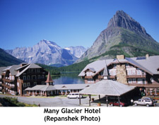
 Leaving the dispute behind, I
head to Babb, north of St. Mary, where the simply named “Glacier Route
Three” leads me 12 miles west back into the park to Many Glacier with its
magnificent four-story lodge set along the shore of Swiftcurrent Lake.
Opened in 1915, the Swiss alpine-themed Many Glacier Hotel is ringed by
craggy mountains. Though the rooms are small and cramped, the lodge is a
great base for wilderness forays, day hikes and paddles across the lake.
Down at the dock, a scenic cruise is ready to embark on a trip across
Swiftcurrent Lake, while a family launches a canoe and kayak into the water.
On the far shore, a bull moose is knee-deep in water, taking his morning
breakfast from the lakebed vegetation. I gaze at the surrounding mountains,
longing to see more of this wondrous landscape. But the rest of Glacier is
too expansive to fully sample in one week. Rather, like a rich chocolate
mousse cake, the park is to be taken a slice at a time and savored.

 Support Essential Coverage of Essential Places


Comments