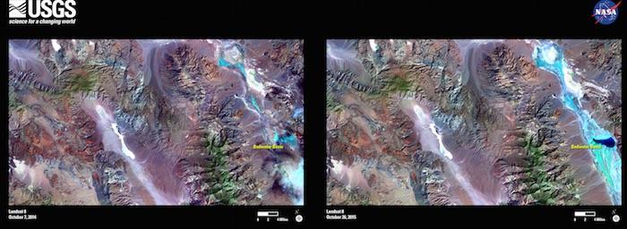
In this image pair Landsat 8 images contrast October 2014 (on left, a year with typical precipitation) to October 2015. The false color images highlight hydrogeology; the areas in green to blue are the locations with moisture content. Especially striking is the Badwater Basin, normally a dry lake bed. In the 2015 image, it is full of water/USGS
Editor's note: This cleanup story is continuing to develop, and we'll post updates as they are made available.
Mud-filled buildings, roads cleaved in half, electricity out. Two weeks after the "largest flood event in recorded history of the area" washed through Death Valley National Park, officials are formulating a recovery plan that likely will take months and tens of millions of dollars to carry out.
Perhaps worst-hit by the storm October 18 was Scotty's Castle, an historic highlight in Death Valley's history. The castle is a magnificent mansion in the northern end of the park up Grapevine Canyon. Built back in 1922 by Albert Johnson, a Chicago insurance tycoon, the castle-like structure is named after Walter Scott, a desert rat who made a living by convincing investors to stake his supposed prospecting in Death Valley.
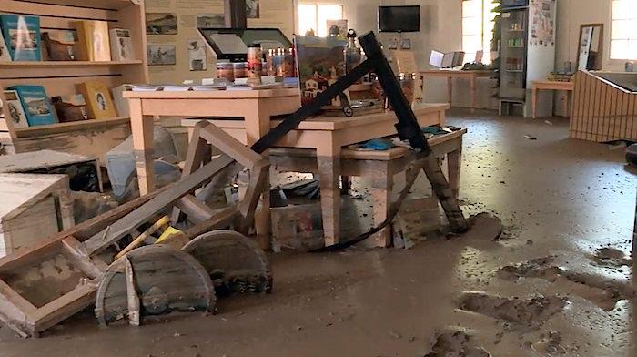
Today the mansion is bruised and battered. An outbuilding used for the visitors center has a thick layer of mud on the floor and water damage. Some exterior walls of the mansion have mud almost half-way up doors. Ten miles of highway CHECK leading to the complex, located in Grapevine Canyon, were swept away.
For an area that only receives about 2 inches of rain a year, the 1-2 inches that fell from a series of stormes that passed over Death Valley in mid-October were devastating. As the USGS Landsat images above show, the Badwater Basin, which normally is a dry lakebed, was still full of water from the flood on October 26, eight days after the storms hit.
The largest of the storms occurred on October 18. Flash floods from the storm destroyed roads and utilities, and damaged several historical structures. This was the largest flood event in the recorded history of the area. -- USGS

The storms left the visitors center at Scotty's Castle filled with mud/NPS

Floodwaters affected 10 miles of roads in Death Valley National Park/NPS

Mud nearly reached door handles outside Scotty's Castle/NPS

Scotty's Castle in better times.


Comments
How about volunteers?
It would be helpful for this blog and/or the NPS on the Death Valley official site to post exact and accurate information about what roads are washed out, where, if local detours are not in place (from the damage you show, I'd guess driving around on a temporary road isn't happening). I have been planning a trip there this winter (December) and it is not as though it's easy to turn around and go somewhere else in Death Valley, given the limited availability of gas and accommodations in the area.
Here's your road conditions list: (You can check more regularly by visiting the Facebook page for Death Valley Road Conditions, https://www.facebook.com/DeathValleyRoadConditions)
No new updates for 10/30
All roads not mentioned should be considered OPEN such as CA 190. Expect damage on backcountry roads. Damage and closures are due to flood damage.
Badwater Rd. - CLOSED
Big Pine Rd/Death Valley Rd. - Open from Big Pine to South Eureka Valley Rd. Access to the dunes is OPEN. The road is closed from South Eureka Valley Rd to Ubehebe/Scotty's Castle area.
Hole in the Wall Rd. - CLOSED
Greenwater Road/Furnace Creek Wash Road is OPEN from Dante's View Rd, but the intersection of Greenwater/Furnace Creek Wash Road and Badwater/178/Jubille Pass Road is closed. No thru traffic.
Lower Wildrose Rd. - CLOSED from Wildrose Campground to Panamint Valley. Access to the Wildrose area is necessary via Emigrant Canyon Road.
Mustard Canyon Rd. - CLOSED
Salt Creek Rd. - CLOSED
Racetrack Rd. - CLOSED
Saline Valley Rd (North Pass) - CLOSED
Scotty's Castle Rd - Open to the intersection of Titus Canyon. CLOSED going North.
20 Mule Team Canyon - CLOSED
Ubehebe Crater Rd - CLOSED
Saratoga Springs Road is impassable between Harry Wade Road and the Ibex Spring road junction.
All roads not mentioned should be considered OPEN such as CA 190. Expect damage on backcountry roads. Damage and closures are due to flood damage.
There is no estimated date for opening roads. Road crews from Joshua Tree National Park, Lake Mead, and Death Valley are working hard to clear debris and repair flood damage. Thank you for your patience.
Thank you! That's very helpful. Not everyone uses Facebook.