"The most extravagantly beautiful," Mount Rainier National Park / Rebecca Latson
As you drive toward, or fly over, Washington state, you can’t help but turn your eyes toward “The Mountain.” Known as Tahoma (or Tacoma) by the Northwest Native tribes and “an icon in the Washington landscape,” this “episodically active” volcano and most-glaciated peak in the contiguous U.S. lends its name to Mount Rainier National Park, which offers visitors plenty of activities surrounding this centerpiece mountain. The Traveler’s Checklist can help you plan your trip to make the most of your time exploring this park.

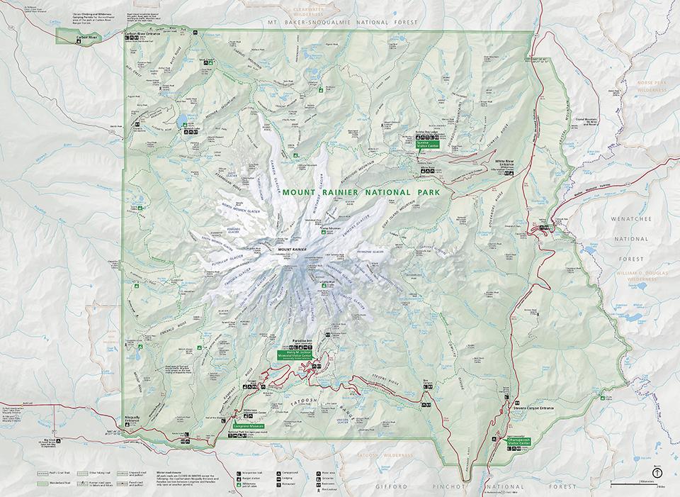
Map of Mount Rainier National Park / National Park Service
- Mount Rainier is unusual among NPS units in having five entrances, but only three official entrance stations: White River/Sunrise, Stevens Canyon, Nisqually. Carbon River and Mowich Lake roads (SR 165) deadend just inside the park's northwestern corner. State Route 410 follows the White River up from Puget Sound and enters the park at the northeastern corner, then exits across the eastern boundary at Chinook Pass; The White River entrance station is on a spur road off State Route 410 to the Sunrise developed area. State Route 123 crosses the southeastern boundary north of Packwood, Washington, and merges with State Route 410 at Cayuse Pass. Stevens Canyon entrance station is at the east end of the road of that same name connecting from State Route 123 to Paradise and Nisqually entrance. All of the above roads except Carbon River are unplowed and closed by deep snow for about half of each year. The Carbon River Road was washed out by a 2006 flood and is closed to cars beyond the park boundary, but open to bicycle and pedestrian traffic. The Nisqually entrance (SR 706 via SR 7) is the only park entrance open during the winter.
- The park’s Nisqually Entrance is a little under two hours’ drive from the Seattle-Tacoma International Airport, and a little more than two hours’ drive from the Portland International Airport.
- Operated by Mount Rainier Guest Services, there are two in-park brick-and-mortar lodges: Paradise Inn and National Park Inn. Both are very popular and reservations are advised way ahead of your actual trip. Outside the park’s Nisqually Entrance are a number of lodging options in the small community of Ashford, while Packwood 13 miles (20.9 km) south of the Stevens Canyon Entrance has quite a bit of lodging. The Crystal Mountain Resort area offers lodging about 10 miles (16.1 km) from the White River Entrance.
- There are four campgrounds -- three drive-in, one walk-in -- in the park. “Although campsites are available on a first come, first served basis, you can reserve sites at the Cougar Rock and Ohanapecosh Rock campgrounds by visiting the Recreation.gov web site.”
- Make sure your gas tank is full. There are no in-park gasoline stations. Greenwater, a little over 20 miles (32.2 km) north of the White River Entrance, is the closest place to tank up outside the eastern side of the park. Ashford has a very small gas station and Morton, about 30 miles (48.3 km) from the Nisqually Entrance, offers more gasoline options. You also can refuel at Packwood, roughly 13 miles (20.9 km) south of the Stevens Canyon Entrance.
- Stop at the pullouts and view areas for scenes of rivers, streams, and landscape vistas with and without views of Mount Rainier. You’ll see different environments as you progress from low to high elevations. A couple of must-see stops include Glacier Bridge, about 5 miles (8.05 km) up the road from Longmire. DO NOT stop on the bridge. Instead, park in the large lot to your right, just before crossing the bridge on your way to Paradise. Or at the large pullout to your left, just before the bridge as you make your way down from Paradise. You’ll see up and down the Nisqually River’s route from the Nisqually Glacier at this spot. Drive about a mile (1.61 km) or so further up the road and take the short, one-way Ricksecker Point loop drive, parking in the lot at the beginning of the loop for an overhead view of Glacier Bridge and the Nisqually River way down below.
- Go hiking. There are a multitude of day hike options from which to choose. If you are only there for a day and have time for just one hike, here are a few suggestions. If you are visiting the Sunrise area (White River Entrance), hike the Sourdough Ridge trail or the Burroughs Mountain trail for amazing views of the northeastern side of Mount Rainier.
Up at Paradise, any of those trails are great and most of them are paved for a distance. You’ll get awesome close-up views of Nisqually Glacier and the south-southeast side of Mount Rainier along those trails. Probably the most popular trail up at Paradise is the 5.5-mile (8.85 km) Skyline Loop, paved near the beginning and later turning into dirt and gravel as it wends its way to the aptly-named Panorama Point, with views of the Tatoosh Range, Paradise Inn, the winding trails back down to the inn, and, on a clear day, “views of peaks as far south as Oregon’s Mount Hood.” From there, you can retrace your steps back to Paradise Inn, or continue along the loop. The Paradise trails are steep in places and the higher altitude makes drawing a breath a little more labor-intensive, so take your time, drink plenty of water, and enjoy the views.
A great introduction to the low-elevation interior forest of the park is the easy 0.4-mile (0.64 km) Twin Firs loop trail, located to your left along the park road toward the Longmire Historic District. As you walk along the sun-and-shade-dappled forest trail past nurse logs and mossy trees, you’ll smell the scent of pine and cedar and hear the musical monologue of birds hidden within the shadows. Once you reach the Longmire area (Nisqually Entrance), park your vehicle in the National Park Inn’s parking lot and take the popular and easy 0.7-mile (1.1 km) Trail of Shadows loop around Longmire Meadow. Depending upon the time of year, you might see small pools of bubbling water along the trail, indicators of Mount Rainier’s underground volcanic activity.
An extremely popular trail accessed via the Stevens Canyon Entrance is the Grove of the Patriarchs trail in the Ohanapecosh area. This 1.3-mile (2.1 km) roundtrip hike will take you over the Ohanapecosh River via a suspension bridge and through old-growth forest to a grove of giant trees, some of them more than 300 feet (91.4 m) tall and a couple of them about 1,000 years old. Traveler's Note: The Grove of the Patriarchs Trail is closed until further notice due to damage to the suspension bridge crossing the Ohanapecosh River. The Bench and Snow Lake trail along the Stevens Canyon Highway toward the turnoff to Paradise, is a very popular 2.5-mile (4 km) roundtrip hike, and there’s a wilderness camp at Snow Lake, for which you’ll need a wilderness permit if you intend to set up a tent there.
If you are in the Carbon River area (the road is only open to hiking and bicycling), an easy trail to take is the very short 0.25- mile (0.4 km) Rainforest Loop trail. A popular longer, more strenuous trail to take is the 5.6-mile-roundtrip (9 km) Tolmie Peak trail in the Mowich Lake area.
If you’re looking to hike backcountry on the 93-mile (149.7 km) Wonderland Trail, you’ll need a wilderness permit for backcountry camping. - Speaking of the Longmire Historic District, stop and visit the museum to learn about the early days of the park, then stretch your legs for a walk or go on a bicycle along Longmire Road and cross the Longmire suspension bridge spanning the Nisqually River.
- Learn about glaciers and use your binoculars or telephoto lens for close-ups of crevasses, huge blocks of ice, and moraines. Mount Rainier has 28 named glaciers along with numerous unnamed snow fields. Two glaciers with view areas and trails for close-up views are the Nisqually Glacier in the Paradise area and Emmons Glacier in the Sunrise area. In the Sunrise area, walk the short distance from the parking lot to Emmons Vista, “the largest glacier by area not only on Mount Rainier but also in the contiguous United States.” The view area is small and can get crowded, but if you visit early in the morning, during and after sunrise, you might have it all to yourself. From there, take the trail toward Sunrise Camp, then branch onto the trail to Glacier Overlook. Take the rim trail toward the Burroughs for even closer views of Emmons Glacier.
- Go bicycling. While there are no designated bike trails, bicycles are allowed on the park roads, but are not permitted on any hiking trail. The park roads are narrow, winding, steep, and have unpaved shoulders. Cyclists must ride single file and obey the rules of the road. Click here to read bicycle safety and regulations for the park.

A nameless waterfall along Westside Road near the Nisqually Entrance, Mount Rainier National Park / Rebecca Latson
- Watch for waterfalls. Because of Mount Rainier’s glaciers and snowpack, there are an “untold number” of waterfalls, named and unnamed. Just prior to the Bench and Snow Lake trail pullout/parking area along Stevens Canyon is Sunbeam Falls along Sunbeam Creek. If you are driving the Longmire-to-Paradise-Corridor road, you’ll be able to view two of the most popular waterfalls in the park: Christine Falls and Narada Falls. Get there early, because parking fills up quickly for both of these waterfalls. Parking for Christine Falls is really small, and you should slow down and watch for people walking alongside the road in that area. Another popular waterfall is Myrtle Falls, located on a paved trail just 0.4 mile (0.64 km) from Paradise Inn. Early morning is the best time to view this waterfall before the crowds start gathering around the tiny view area. If you are photographer, waterfalls are great spots to practice your silky water technique.

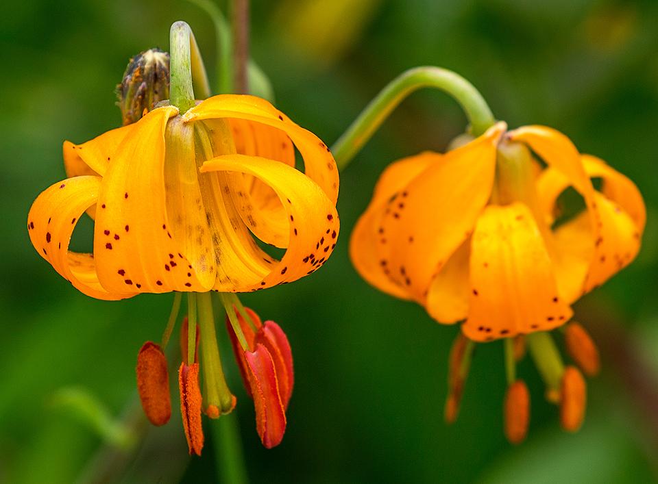
Tiger lilies, Mount Rainier National Park / Rebecca Latson
- Look for wildflowers. Peak bloom is difficult to predict since it’s dependent upon weather and precipitation patterns, but generally, you’ll see a plethora of wildflowers between mid-July into August, including glacier lilies, avalanche lilies, beargrass, phlox, tiger lilies, scarlet and magenta paintbrushes, and penstemons. If you plan on some wildflower photography, bring along your SLR’s macro or telephoto lens for close-ups, or use the macro mode on your point-and-shoot camera. Smartphones also work well for close-ups.
- Bring your binoculars or telephoto lens and be on the lookout for birds. You might spot Steller’s jays, owls, hawks, grouse, dark-eyed juncos, ravens, Canada jays, and many other birds in this national park. I’ve seen ravens and Steller’s jays everywhere in the park, grouse and dark-eyed juncos up at Paradise, and Canada jays in the Sunrise area. It's possible to see five different Corvids ( Stellers & Gray jays, crows & ravens, & Clark's Nutcracker) at any of the subalpine attractions.

Little red fox on a log, Mount Rainier National Park / Rebecca Latson
- Keep those binoculars and your telephoto lens handy for spotting wildlife, in addition to birds. You might see black bears, foxes, deer, pikas, marmots, and, if you are really lucky, an elusive pine martin, among the wildlife that calls Mount Rainier home. I’ve seen fox at both the Longmire Historic District and up at Paradise, marmots all along the higher elevations, and black bears at both Paradise and Sunrise.
- Go fishing. Know before you go. You can download a fishing pamphlet of what you might catch as well as regulations for fishing in the park.
- Climb Mount Rainier. It’s quite an achievement to be able to say you’ve climbed this 14,410-foot-tall (4,392 m) volcano. Climbing “The Mountain” takes planning and preparation and is not something to do on the spur of the moment. Click here for route descriptions and minimum requirements, and click here for guide services and solo permit requests.

The end of night and beginning of dawn over Reflection Lakes, Mount Rainier National Park / Rebecca Latson
- Go stargazing and photograph the stars and Milky Way at spots along the Stevens Canyon Road, at Reflection Lakes, or up at the Paradise or Sunrise areas. For tips on night photography, click here.
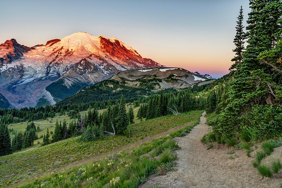
- If you can’t stay up past dark for any stargazing, then get up early to go view (and photograph) a sunrise. Reflection Lakes, any of the trails with mountain views up at Paradise and Sunrise are great places for capturing the start of a new day in the park.

Winter at Paradise, Mount Rainier National Park / Rebecca Latson
- Visiting Mount Rainier National Park during winter offers a different perspective of the park and opens up all sorts of snowshoeing, cross-country skiing, and sledding activities. The Nisqually Entrance is open year-round, as is the National Park Inn at Longmire. While you may not see as much snow in the lower elevations, there is plenty up at Paradise. During the winter, however, the gate to Paradise at Longmire is closed until after snow plows have cleared the route to, and parking lot at, Paradise. Sometimes winter weather dictates the gate remaining closed throughout the day You’ll need to carry tire chains in your vehicle, because the road past Longmire is snowy and icy, narrow and winding. Keep checking the park’s website, as well as their Instagram account (@mountrainiernps) and Facebook and Twitter pages (@MountRainierNPS) for winter updates.
- Before you go on your trip, remember to check the park’s website to find out if and where pets are allowed and whether or not there are any closures or restrictions due to construction or weather.
- Remember to pack sturdy hiking footwear. With the exception of the paved trails up at Paradise, most of the trails have rocky, uneven areas to navigate and flip flops and regular sandals, not to mention tennis shoes with no tread are invitations to accidents and ankle injuries, no matter how sure-footed you think you are.
- To check on how things look prior to your park outing, here’s a handy series of webcams. Be aware however, that higher-elevation weather is variable. A clear, sunny sky can turn into rainfall or snow storm within a matter of minutes. Pack a jacket and maybe some raingear so you won’t be caught unprepared for inclement weather.

Sunrise over the Sunrise area, Mount Rainier National Park / Rebecca Latson

 Support Essential Coverage of Essential Places


Comments
Just beautiful. I wish Mt. Rainier would develop a shuttle system - to and from Seattle and within the park - for those of us who can't drive. I would love to see this park.
GPS navigation systems have apparently been misleading many visitors:
https://twitter.com/MountRainierNPS/status/1405551216944320513