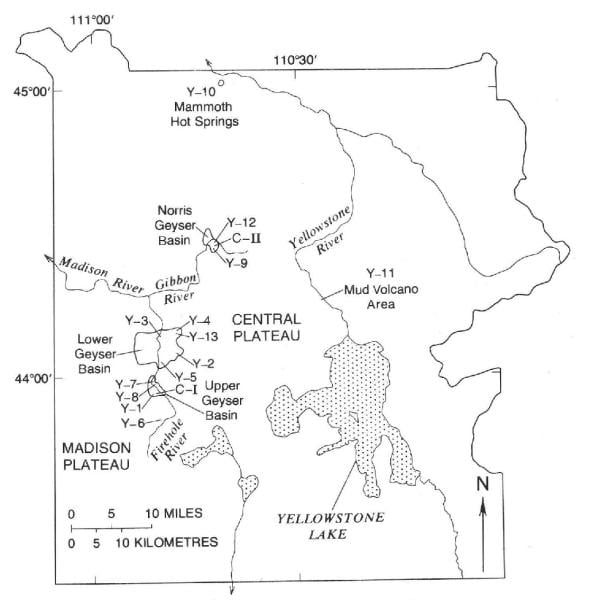
Yellowstone is home to a fascinating array of hot springs, mud pots, frying pans, geysers, and fumaroles, but for a long time it was unknown what was going on beneath the ground surface in the hydrothermal system. U.S. Geological Survey scientists in the 1960s wanted to find out, so they teamed up with the National Park Service and became pioneers in research drilling.
This is the story of the drilling of 13 research cores in Yellowstone National Park during 1967–1968. It’s a story full of excitement, geysering bore holes, discovery, and the matchup of technical knowledge vs. a largely unknown and unpredictable subsurface environment.

Map: Index map showing locations of 1967–1968 research drill holes in Yellowstone National Park. Taken from USGS Bulletin 1967.
Drilling in Yellowstone in the 1960s was a unique operation—not only was the drilling undertaken in one of the largest hydrothermal systems in the world, but the focus of the drilling was on the pursuit of scientific knowledge rather than industrial requirements. Commercial and industrial drilling often overlook non-economically valuable data collection that can have significant scientific value. The research drilling specifically prioritized these scientific objectives.
Goals of drilling included a focus on the shallow portion of the hydrothermal system, continuous drill core recovery to understand the subsurface geology, allowing for drill holes to equilibrate with surrounding subsurface fluids for accurate temperature-depth measurements, and collecting thermal water samples uncontaminated by drilling mud.
But these pioneers couldn't anticipate the drama of drilling in a place as dynamic as Yellowstone, where drill holes are characterized by unusually high wellhead water pressures—in some cases equivalent to a water table ~220 feet (67 meters) above the ground surface. This made the drilling dangerous and challenging.
The first well to be drilled was in 1967 in the Upper Geyser Basin about 50 meters (164 feet) from the pool of Whistle Geyser. In the report on Yellowstone drilling, "Physical Results of Research Drilling in Thermal Areas of Yellowstone National Park, Wyoming," published as USGS Professional Paper 892, Don White and his colleagues gave this first-hand account:
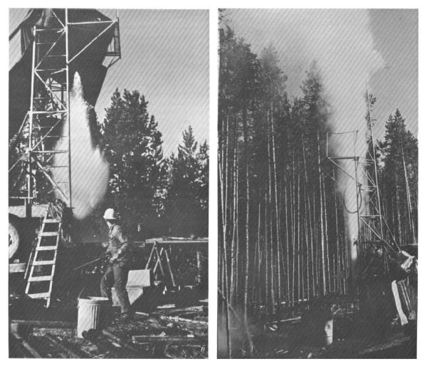
"Eruption tendencies of Y-1 first became evident near -180 ft…. When the core barrel was withdrawn from -215 ft, cool drill water gushed from the [drill] rods in response to the high wellhead water pressures…. Within a few seconds the top cool water was followed by a mixture of boiling water and steam, and the well surged into violent eruption—a shattering experience for all of us! The eruption had the ‘bursting’ characteristics of many geysers of high temperature and abundant water supply [and] boiling water and steam covered the drilling platform."

Eruptions from drill rods during research drilling in Yellowstone National Park, 1967–1968. Left panel shows initial explosive eruption of water-steam mixture from open drill pipe in drill hole Y-5 (Rabbit Creek) on August 20, 1967. The "bursting" effect results from flashing of superheated water erupted to atmospheric pressure at and just above the top of the drill pipe. The eruption phase typically follows a brief interval of quiet overflow and passes rapidly into the near-vertical ejection of steam and water. Right panel shows just such an eruption of water and steam above the top of the drill tower in the Y-9 drill hole, Norris Geyser Basin. Taken from USGS Professional Paper 892.
The scientists and drillers involved in the drill coring campaign of 1967–1968 went on after this first hole to drill 12 more, developing strategies for safely working in this dynamic environment and recording incredible gradients of increasing pressure and temperature with depth.
Collectively, approximately 6,800 feet (about 2,070 meters) of the Yellowstone subsurface was drilled across those 13 locations. A significant portion of foundational knowledge that scientists have regarding active hydrothermal systems, shallow hydrothermal alteration, and Yellowstone’s hydrology can be traced back to the physical measurements taken while drilling these cores and the subsequent study of minerals in recovered cores.
The information gained is still paying dividends today. Although major drilling projects are unlikely to be permitted in the future in Yellowstone to preserve the exceptional hydrothermal system, the cores that were drilled in the late 1960s are still stored at the USGS Core Research Center where scientists continue to examine them today, unlocking more secrets held in stone.


 Support Essential Coverage of Essential Places


