Editor's note: Yellowstone Caldera Chronicles is a weekly column written by scientists and collaborators of the Yellowstone Volcano Observatory. This week's contribution is from Michael Poland, geophysicist with the U.S. Geological Survey and Scientist-in-Charge of the Yellowstone Volcano Observatory.
The Yellowstone caldera is the most recent in a series of volcanic structures that stretches across the Snake River Plain of Idaho and into northern Nevada. One of the oldest volcanic complexes in that sequence, McDermitt caldera on the Nevada-Oregon border, shares many similarities with Yellowstone.
The Yellowstone hotspot has been around a long time—probably more than 50 million years. It apparently started off the coast of northern California, and motion of the North American plate resulted in volcanism that trended across north and northeastern California and into northern Nevada. Tectonic motion smeared these volcanic products to the north, and they are now found in the Oregon and Washington coast ranges.
About 20–22 million years ago the hotspot waned, probably because ascent of magma to the surface was blocked by a slab of old cold oceanic crust that had been overridden by the North American continent. Magma built up beneath the slab and finally broke through starting almost 17 million years ago with the eruption of the Columbia River Basalts—a massive outpouring of fluid basaltic lava that occurred along most of Idaho’s border with Washington and Oregon and that sent lava flows all the way to the Pacific Ocean.

Map of the northwestern U.S., showing the approximate locations of Yellowstone hotspot volcanic fields (orange) and Columbia River Basalts (gray). Boundary of Yellowstone National Park is shown in yellow. Modified from Barry et al. (GSA Special Paper 497, p. 45-66, 2013), Smith and Siegel (Windows into the Earth: the geologic story of Yellowstone and Grand Teton National Parks: Oxford University Press, 2000), and Christiansen (USGS Professional Paper 729-G, 2001).
A series of more explosive eruptions also began, forming calderas that looked at lot like Yellowstone does today. A line of now-buried caldera systems stretches from the Nevada-Oregon border and across the Snake River Plain of southern Idaho, becoming progressively younger approaching Yellowstone caldera.
The oldest calderas of this trend are located on the Nevada-Oregon border in an area that is the traditional homeland of the Shoshone-Paiute Tribes and near the Fort McDermitt Indian Reservation. And the most spectacular of a possible cluster of a few calderas and their associated ash flow units is McDermitt caldera.
Unlike the calderas of the Snake River Plain, McDermitt caldera is well exposed, and because of extensive mineralization, it has also been well studied. The first eruptions in the region included silica-rich rhyolite lava domes starting about 16.7 million years ago, shortly after the Columbia River Basalt eruptions began in the region. The proportion of rhyolite lava flows steadily increased over the ensuing hundreds of thousands of years until the formation of McDermitt caldera in a massive eruption approximately 16.4 million years ago.
The eruption emitted about 1000 km3 (240 mi3) of material—about the same as was erupted during the formation of Yellowstone caldera 631,000 years ago. The resulting collapse left a structure that looked like a keyhole, wider at the north (30 km, or 19 mi) than at the south (22 km, or 14 mi). The north-south caldera length is about 40 km (25 mi). For comparison, Yellowstone caldera is about 70 x 45 km (43 x 28 mi).
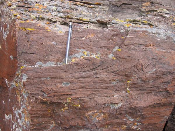
Most of the ash erupted in the explosion fell back into the caldera, which might have been as much as a kilometer (half a mile) deep. Both inside and outside the caldera, the hot ash, which was sourced from an unusually hot rhyolitic magma chamber, flowed under its own weight as it was deposited. This “rheomorphism,” as the process is called, resulted in spectacular formations of folded layers within the deposit, making it very difficult to distinguish from lava flows in some areas. Hydrothermal fluids circulated throughout the caldera and especially along the ring faults. In places, this resulted in major ore deposits—mercury and uranium were mined in several areas of the caldera (the aftermath of the mercury mining has required significant environmental recovery efforts).

Folds in outflow sheets of McDermitt Tuff, from the eruption that formed McDermitt Caldera in Nevada and Oregon about 16.4 million years ago. The folding is called “rheomorphism” and occurred as the hot ash deposit flowed under its own weight shortly after it was deposited over preexisting topographic highs and lows. The texture resembles that of rhyolite lava flows, making it very difficult to distinguish lava and ash deposits in this area. This example is from the Double H Mountains south of the caldera/Chris Henry, Nevada Bureau of Mines and Geology.
As is common at collapse calderas, an episode of resurgent doming occurred soon after caldera formation, with the magma chamber recharging and pushing the ground upward. Rhyolite and more fluid basaltic lava flow eruptions occurred in the 300,000 years after caldera collapse as well, ceasing by about 16.1 million years ago.
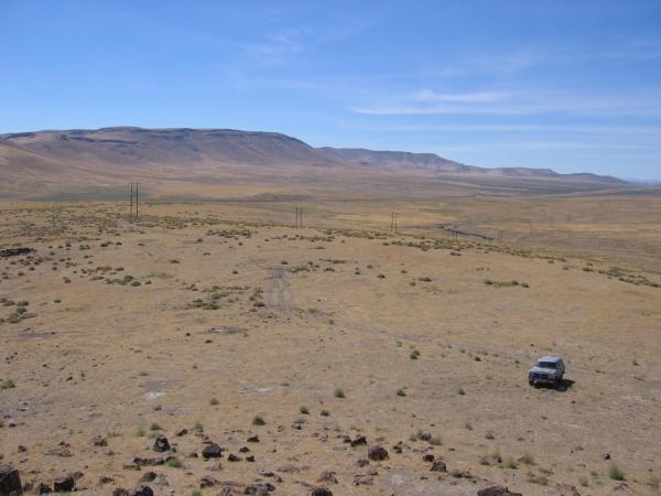
Soon after the collapse of McDermitt caldera, a lake formed in the enclosed basin, as indicated by thick accumulation of lake sediments. While the lake was present, the thick ash deposit from the caldera eruption continued to cool and release gases and briny solutions that mixed with hydrothermal fluids associated with the underlying magma chamber. The fluids leached compounds like lithium from the recently erupted volcanic rock. As the lithium-rich gas and brine reacted with the lake water, lithium became enriched in clay minerals within the lake sediment—a deposit that was documented by USGS geologists in the 1970s.

View from the SE rim of McDermitt caldera, Nevada and Oregon, showing rhyolite lavas overlain by thin outflow McDermitt Tuff in the south wall of the caldera. The low area that makes up most of the photo is intracaldera tuffaceous sediment. This is Thacker Pass, the site of largest and highest-grade lithium deposits in the region/Chris Henry, Nevada Bureau of Mines and Geology.
Many of the conditions that existed at McDermitt caldera can be found today on the floor of Yellowstone Lake, where high-temperature hydrothermal fluids are emitted from vents on the lake floor. By the same token, McDermitt caldera has many similarities with calderas across the Snake River Plain and can be used as an analog to better understand those systems.
To see a geologic depiction of McDermitt caldera, check out the map prepared by Nevada Bureau of Mines and Geology scientists as a supplement to their article "Geology and evolution of the McDermitt caldera, northern Nevada and southeastern Oregon, western USA" (https://doi.org/10.1130/GES01454.1).


 Support Essential Coverage of Essential Places


Comments
Many thanks to the author and NPT for sharing this story. It's the best summary of Northwest Cenozoic geology I have seen!