Editor's note: Yellowstone Caldera Chronicles is a weekly column written by scientists and collaborators of the Yellowstone Volcano Observatory. This week's contribution is from Michael Poland, geophysicist with the U.S. Geological Survey and Scientist-in-Charge of the Yellowstone Volcano Observatory.
You’ve heard the word before: “caldera.” As in Yellowstone caldera. Or Kīlauea caldera. But what does that mean, really? To geologists, the term refers to both a type of volcano as well as a structure that results from volcanic activity, and it is distinct from the term “crater.”
“Crater” is a somewhat generic term referring to an enclosed depression in the ground that can have several possible origins, volcanic and otherwise. By strict definitions, a caldera is a type of crater, but calderas are distinguished by their large sizes and specific association with volcanic collapse.
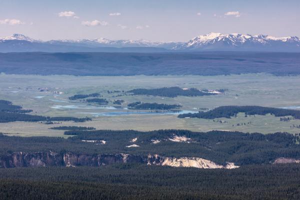
Yellowstone is a caldera. The eruption that occurred 631,000 years ago largely emptied the magma chamber, and the ground collapsed into the resulting void. Yellowstone caldera is gigantic—about 70 by 45 kilometers (43 by 28 miles).

View of the Yellowstone caldera from the Washburn Range -- the scene described by Lieutenant Doane of the Washburn expedition in 1870. The caldera extends to the base of the Red Mountains in the upper right of the photo. The rim of the Grand Canyon of the Yellowstone is in the foreground. National Park Service photo by Jacob Frank, July 1, 2017.
In the language of volcanology, a small collapse—perhaps a few hundred meters (yards) across—is a crater. But a large collapse—generally more than 1 kilometer (0.6 mile) across—is a caldera. Guidelines are vague for the size of a crater vs. a caldera. The main point is that a caldera is bigger and a crater is smaller. Craters often form by small evacuations of magma from shallow levels, like the numerous pit craters that dot the surface of Kīlauea, in Hawaiʻi, whereas a caldera results by the partial emptying of a volcano’s main magma chamber. Craters may also encircle a volcano’s throat when material is ejected during explosions, like craters atop many volcanic cones.
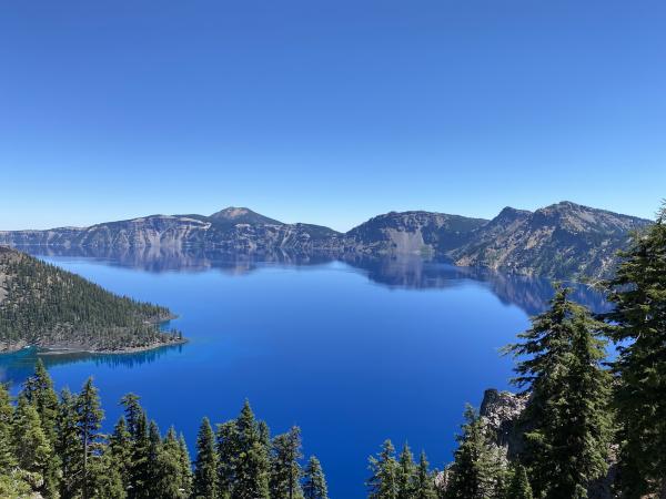
A spectacular caldera example is found in Oregon. About 7,700 years ago, Mount Mazama was the site of a tremendous eruption whose ash covered much of western North America. Mazama ash is even found in sediment cores collected from the floor of Yellowstone Lake! The top of the Mazama volcano collapsed into the emptied magma chamber, leaving a large surface depression that eventually filled with rainwater and became what we know today as Crater Lake.

Crater Lake on a bright clear day in August 2020. Crater Lake inspires awe. Native Americans witnessed its formation 7,700 years ago, when a violent eruption triggered the collapse of a tall peak. Scientists marvel at its purity—fed by rain and snow, it’s the deepest lake in the USA and one of the most pristine on Earth.
Yes, rather confusingly, the landform that defines Crater Lake is a caldera. “Caldera Lake” might be a more accurate name for the place but doesn’t have quite the same ring to it.
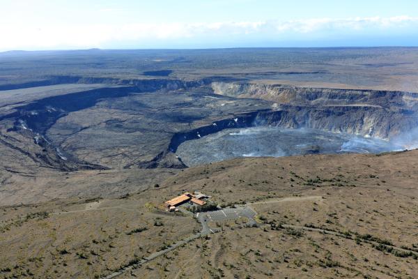
Calderas don’t always form from catastrophic explosive eruptions. The large depressions at the summits of many shield volcanoes, like those in Hawaiʻi, are also calderas. In fact, in 2018, a large eruption of lava at Kīlauea volcano partially emptied the magma chamber and caused the summit to collapse, forming a smaller caldera within the larger summit caldera. The collapse wasn’t instantaneous but rather occurred in piecemeal fashion, with discrete down-dropping events interspersed with steady sinking. Over the course of about 3 months, the summit collapsed by more than 500 meters (1600 feet). Similar collapses have occurred at Barðarbuga, Iceland (2014–2015), Piton de la Fournaise, Reunion Island (2007), Miyakejima, Japan (2000), and Fernandina, Galápagos (1968).

Hawaiian Volcano Observatory geologists captured this view of the caldera at Kīlauea summit during an overflight the morning of July 19, 2022. The active lava lake is visible within Halema‘uma‘u crater, the floor of which continues to slowly rise as the eruption continues. The former Hawaiian Volcano Observatory buildings can be seen in the lower center portion of the photo. USGS image by K. Mulliken.
To geologists, “caldera” also can refer to a style of volcanism, and Yellowstone is a perfect example. There has never been a massive volcanic edifice dominating the landscape at Yellowstone. It never looked like Mount Mazama did before that volcano collapsed. Rather, Yellowstone is a volcanic field, with numerous eruptive vents spread out across the landscape, reflecting the large and complex reservoir of magma that lies beneath the ground and that fed the eruption that formed the caldera.
So Yellowstone is not a stratovolcano. It’s not a shield volcano. It’s not a cinder cone or a lava dome or a coulee or a plug. Rather, it demonstrates a style of volcanism that includes rare large explosive eruptions associated with caldera collapse, preceded and followed by smaller eruptions. Other caldera complexes in the United States include Valles in New Mexico and Long Valley in California. Beyond the United States, caldera complexes are typified by Taupō in New Zealand and Campi Flegrei in Italy.
It's admittedly not an elegant terminology, but now you know how geologists use the term “caldera”—to describe both a large crater that results from collapse into an evacuated magma chamber, and also a type of volcano with no main central vent and that has experienced huge eruptions in the past.


 Support Essential Coverage of Essential Places


